Loading...
Done
An alarmed squirrel. (Photo by Mary McGowan/Barcroft Images/Comedy Wildlife Photography Awards)

An alarmed squirrel. (Photo by Mary McGowan/Barcroft Images/Comedy Wildlife Photography Awards)
Details
17 Sep 2018 00:03:00
Filipinos riding on makeshift carts cross over an overflowing dam during a downpour in Las Pinas city, south of Manila, Philippines, 05 September 2017. According to the latest forecast from the Philippine Atmospheric Geophysical and Astronomical Services Administration (PAGASA) state weather bureau, typhoon signals were raised over Northern Luzon brought by a tropical storm (local name: Tropical Storm Kiko) and warned fisherfolks and small seacrafts not to venture onto the sea due to big waves. (Photo by Francis R. Malasig/EPA/EFE)

Filipinos riding on makeshift carts cross over an overflowing dam during a downpour in Las Pinas city, south of Manila, Philippines, 05 September 2017. According to the latest forecast from the Philippine Atmospheric Geophysical and Astronomical Services Administration (PAGASA) state weather bureau, typhoon signals were raised over Northern Luzon brought by a tropical storm (local name: Tropical Storm Kiko) and warned fisherfolks and small seacrafts not to venture onto the sea due to big waves. (Photo by Francis R. Malasig/EPA/EFE)
Details
06 Sep 2017 09:06:00
This handout picture taken by Pleiades satellite and released on September 27, 2013 shows a small island of mud and rock created by the huge earthquake that hit southwest Pakistan has fascinated locals but experts – who found methane gas rising from it – say it is unlikely to last long

This handout picture taken by Pleiades satellite and released on September 27, 2013 shows a small island of mud and rock created by the huge earthquake that hit southwest Pakistan has fascinated locals but experts – who found methane gas rising from it – say it is unlikely to last long. The 7.7-magnitude quake struck on September 25 in Baluchistan's remote Awaran district, killing at least 271 people and affecting hundreds of thousands. The island is about 60 to 70 feet (18 to 21 metres) high, up to 300 feet wide and up to 120 feet long and sits about 650 feet from the coast. (Photo by AFP Photo/CNES/Distribution Astrium Services)
Details
01 Oct 2013 08:23:00
London 2012 – UK Landmarks: Gloucester Cathedral

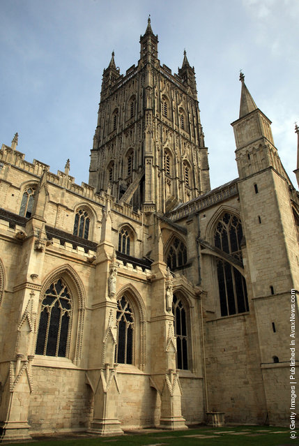
“Gloucester Cathedral, or the Cathedral Church of St Peter and the Holy and Indivisible Trinity, in Gloucester, England, stands in the north of the city near the river. It originated in 678 or 679 with the foundation of an abbey dedicated to Saint Peter (dissolved by King Henry VIII)”. – Wikipedia

Photo: A general view of Gloucester Cathedral is seen on March 22, 2012 in Gloucester, England. With only a few months to go until the opening ceremony of the London 2012 Olympic games, Britain's tourist industry is hoping to benefit from the influx of athletes, officials and visitors. (Photo by Matt Cardy/Getty Images)
Details
26 Mar 2012 10:30:00
Barcelona's Traditional Christmas Swimming Cup

A competitor dressed up as Santa Claus jumps into the sea during the 102nd Barcelona Traditional Christmas Swimming Cup at the Old Harbour of Barcelona on December 25, 2011 in Barcelona, Spain. (Photo by David Ramos/Getty Images)
Details
26 Dec 2011 12:26:00
Visitors at the National Zoo check out a parrotfish made from found waste from the ocean in Washington, DC on May 23, 2016. The artwork can be seen at the National Zoo until September 5th. (Photo by Keith Lane/The Washington Post)

Visitors at the National Zoo check out a parrotfish made from found waste from the ocean in Washington, DC on May 23, 2016. The artwork can be seen at the National Zoo until September 5th. (Photo by Keith Lane/The Washington Post)
Details
25 May 2016 13:11:00
From Britain to China to Mali, new maps showing travel times to the nearest urban centre reveal huge differences between countries. Using Open Street Map and Google, a University of Oxford team have created a visual breakdown that suggests major inequalities when it comes to commuting. Here: China. The dataset used for China was unique as it relied solely on Open Street Map, due to restrictions on accessing Google data. The population is densely concentrated in the east and accessibility is increased, whereas rural provinces in the west remain remote. (Photo by Daniel Weiss/Jennifer Rozier/Malaria Atlas Project/University of Oxford )

From Britain to China to Mali, new maps showing travel times to the nearest urban centre reveal huge differences between countries. Using Open Street Map and Google, a University of Oxford team have created a visual breakdown that suggests major inequalities when it comes to commuting. Here: China. The dataset used for China was unique as it relied solely on Open Street Map, due to restrictions on accessing Google data. The population is densely concentrated in the east and accessibility is increased, whereas rural provinces in the west remain remote. (Photo by Daniel Weiss/Jennifer Rozier/Malaria Atlas Project/University of Oxford)
Details
12 Jan 2018 06:43:00
A sanitation worker fumigates using sodium hypochlorite in an archive room to fight the spread of the coronavirus disease (COVID-19) in the Milimani commercial courts in Nairobi, Kenya, July 17, 2020. (Photo by Baz Ratner/Reuters)

A sanitation worker fumigates using sodium hypochlorite in an archive room to fight the spread of the coronavirus disease (COVID-19) in the Milimani commercial courts in Nairobi, Kenya, July 17, 2020. (Photo by Baz Ratner/Reuters)
Details
20 Jul 2020 00:07:00