Loading...
Done
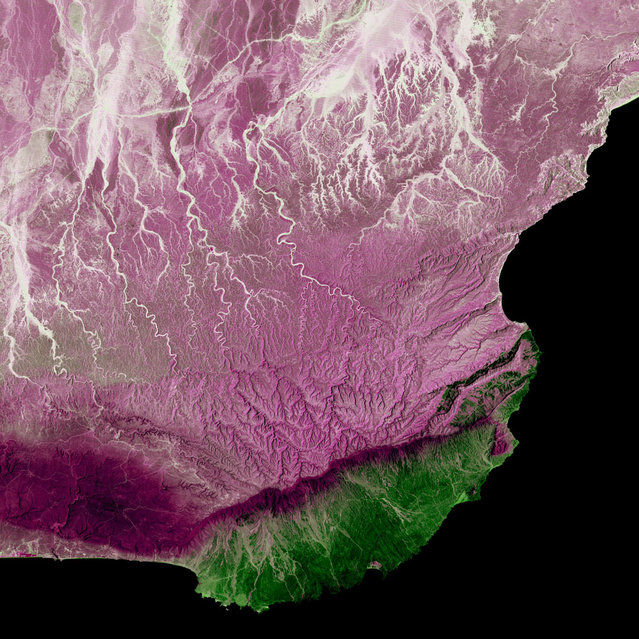
Dhofar Region, Oman. Much of Oman is desert, but the Arabian Sea coast in the Dhofar region represents a startling difference in climate. This coastal region catches the monsoon rains, or khareef, during the summer months. Drenching rains fall primarily on the mountainous ridge that separates the lush, fertile areas along the coast from the arid interior, recharging streams, waterfalls and springs that provide plentiful water supplies in the fertile lowlands for the remainder of the year. Image taken by Landsat 5 on April 2, 2005. (Photo by USGS/NASA)

Dhofar Region, Oman. Much of Oman is desert, but the Arabian Sea coast in the Dhofar region represents a startling difference in climate. This coastal region catches the monsoon rains, or khareef, during the summer months. Drenching rains fall primarily on the mountainous ridge that separates the lush, fertile areas along the coast from the arid interior, recharging streams, waterfalls and springs that provide plentiful water supplies in the fertile lowlands for the remainder of the year. Image taken by Landsat 5 on April 2, 2005. (Photo by USGS/NASA)
Details
25 Dec 2012 11:13:00
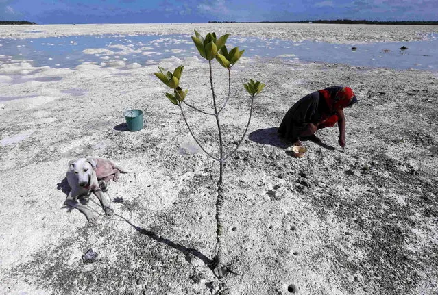
A dog sits in the shade of a mangrove tree as a woman uses a fork to dig for shellfish on the reef-mud flats of a lagoon located at South Tarawa in the central Pacific island nation of Kiribati May 23, 2013. (Photo by David Gray/Reuters)

A dog sits in the shade of a mangrove tree as a woman uses a fork to dig for shellfish on the reef-mud flats of a lagoon located at South Tarawa in the central Pacific island nation of Kiribati May 23, 2013. Kiribati consists of a chain of 33 atolls and islands that stand just metres above sea level, spread over a huge expanse of otherwise empty ocean. With surrounding sea levels rising, Kiribati President Anote Tong has predicted his country will likely become uninhabitable in 30-60 years because of inundation and contamination of its freshwater supplies. (Photo by David Gray/Reuters)
Details
13 Jun 2013 09:23:00
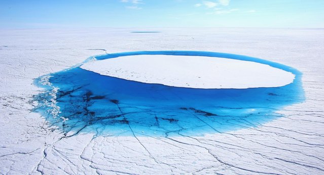
Water is seen on part of the glacial ice sheet that covers about 80 percent of the country is seen on July 17, 2013 on the Glacial Ice Sheet, Greenland. (Photo by Joe Raedle/Getty Images via The Atlantic)

Water is seen on part of the glacial ice sheet that covers about 80 percent of the country is seen on July 17, 2013 on the Glacial Ice Sheet, Greenland. As the sea levels around the globe rise, researchers affilitated with the National Science Foundation and other organizations are studying the phenomena of the melting glaciers and its long-term ramifications. The warmer temperatures that have had an effect on the glaciers in Greenland also have altered the ways in which the local populace farm, fish, hunt and even travel across land. In recent years, sea level rise in places such as Miami Beach has led to increased street flooding and prompted leaders such as New York City Mayor Michael Bloomberg to propose a $19.5 billion plan to boost the citys capacity to withstand future extreme weather events by, among other things, devising mechanisms to withstand flooding. (Photo by Joe Raedle)
Details
02 Aug 2013 10:51:00
An art installation formed with milk churns, made by land art artist Gerard Benoit a la Guillaume, is seen at the Chenau de Mayen in the resort of Leysin, Switzerland August 7, 2015. More than 80 milk churns were placed between the Tour d'Ai and the Tour de Mayen summits at an altitude of 2,000 meters (6,561 feet) above sea level under the direction of the artist, to be photographed for his ongoing art project entitled “Milk churns without borders”. (Photo by Denis Balibouse/Reuters)

An art installation formed with milk churns, made by land art artist Gerard Benoit a la Guillaume, is seen at the Chenau de Mayen in the resort of Leysin, Switzerland August 7, 2015. More than 80 milk churns were placed between the Tour d'Ai and the Tour de Mayen summits at an altitude of 2,000 meters (6,561 feet) above sea level under the direction of the artist, to be photographed for his ongoing art project entitled “Milk churns without borders”. (Photo by Denis Balibouse/Reuters)
Details
08 Aug 2015 13:16:00
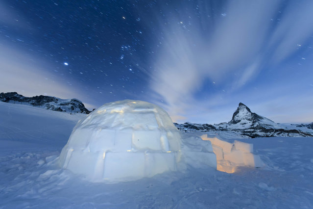
A long time exposure shows a Igloo at the “Igloo village” (Iglu Dorf) in front of the famous Matterhorn mountain in Zermatt, Switzerland, late 28 January 2016. The hotel-igloo village made of snow and ice at 2'815 meters about sea level with a bar, a restaurant, bedrooms and wellness are celebrating their 20th anniversary. (Photo by Jean-Christophe Bott/EPA)

A long time exposure shows a Igloo at the “Igloo village” (Iglu Dorf) in front of the famous Matterhorn mountain in Zermatt, Switzerland, late 28 January 2016. The hotel-igloo village made of snow and ice at 2'815 meters about sea level with a bar, a restaurant, bedrooms and wellness are celebrating their 20th anniversary. For this occasion the hosts built the largest classic igloo with a diameter of 13 meters and a ceiling hight of 11 meters in front of Matterhorn in Zermatt, and they will attempt the world record for this Igloo. (Photo by Jean-Christophe Bott/EPA)
Details
30 Jan 2016 14:16:00
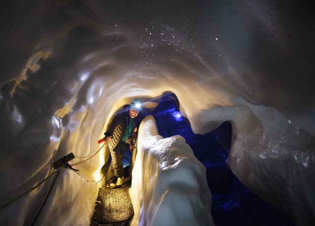
A tourist walks inside the Ice Palace glacier hollow at Hintertux glacier, located at around 3250 meters above sea level, in Zillertal, Austria, 02 March, 2016. The hollow's temperature remains constant at 0 degrees Celsius, in summer and winter alike, and is also used by the University of Innsbruck for scientific research projects. (Photo by Lisi Niesner/EPA)

A tourist walks inside the Ice Palace glacier hollow at Hintertux glacier, located at around 3250 meters above sea level, in Zillertal, Austria, 02 March, 2016. The hollow's temperature remains constant at 0 degrees Celsius, in summer and winter alike, and is also used by the University of Innsbruck for scientific research projects. (Photo by Lisi Niesner/EPA)
Details
03 Mar 2016 11:44:00
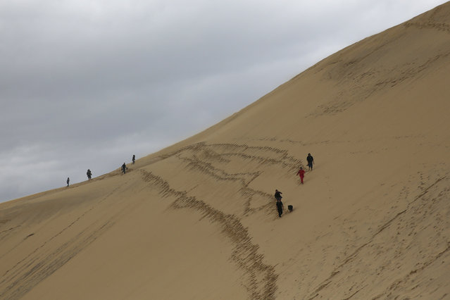
People walk along the Dune du Pilat (Dune of Pilat), the tallest sand dune in Europe, in La Teste de Buch, near Bordeaux, France, June 15, 2016. The dune has a volume of about 60,000,000 m³, measuring around 500 m wide from east to west and 2.7 km in length from north to south. Its height is currently 110 meters above sea level. The dune is a famous tourist destination with more than one million visitors per year. (Photo by Sergio Perez/Reuters)

People walk along the Dune du Pilat (Dune of Pilat), the tallest sand dune in Europe, in La Teste de Buch, near Bordeaux, France, June 15, 2016. The dune has a volume of about 60,000,000 m³, measuring around 500 m wide from east to west and 2.7 km in length from north to south. Its height is currently 110 meters above sea level. (Photo by Sergio Perez/Reuters)
Details
17 Jun 2016 13:38:00
A man from the Dani tribe cuts the head of a pig after cooked by traditional way which is use burned hot stones at Obia Village on August 9, 2014 in Wamena, Papua, Indonesia. The stone-age Dani tribe live a traditional existence in the Baliem Valley, which is situated 1600 metres above sea level in the heart of the Cyclops Mountains. (Photo by Agung Parameswara/Getty Images)

A man from the Dani tribe cuts the head of a pig after cooked by traditional way which is use burned hot stones at Obia Village on August 9, 2014 in Wamena, Papua, Indonesia. The stone-age Dani tribe live a traditional existence in the Baliem Valley, which is situated 1600 metres above sea level in the heart of the Cyclops Mountains. (Photo by Agung Parameswara/Getty Images)
Details
14 Aug 2014 10:30:00