Loading...
Done
Industrial Sector, Tokai, Japan. (Photo by Benjamin Grant/Digital Globe/Caters News)

This series of pictures shot by satellite, show the man-made world as astronauts see it. Artist Benjamin Grant uses Google Earth to find the most compelling satellite images of human civilization. The stunning pictures of sprawling metropolises and vast reservoirs are sometimes unidentifiable until zoomed in. In order to find an extraordinary picture in the practically endless supply of satellite data, Benjamin focuses on the themes of current events or environmental issues. Here: Industrial Sector, Tokai, Japan. (Photo by Benjamin Grant/Digital Globe/Caters News)
Details
04 Feb 2015 12:21:00
An Extinction Rebellion environmental activist couple getting married at an action site they are calling “The Beacon” on Westminster Bridge on October 7, 2019 in London, England. Primarily made up of London based activists the site is one of 12 situated around key Government locations in central London as actions are also predicted to occur in unto 70 cities around the world. The group aim to occupy the areas in central London for up to two weeks through non violent protest with an estimated 8 times as many people as their April protests which saw over 1,200 people arrested. (Photo by Ollie Millington/Getty Images)

An Extinction Rebellion environmental activist couple getting married at an action site they are calling “The Beacon” on Westminster Bridge on October 7, 2019 in London, England. Primarily made up of London based activists the site is one of 12 situated around key Government locations in central London as actions are also predicted to occur in unto 70 cities around the world. The group aim to occupy the areas in central London for up to two weeks through non violent protest with an estimated 8 times as many people as their April protests which saw over 1,200 people arrested. (Photo by Ollie Millington/Getty Images)
Details
10 Oct 2019 00:05:00
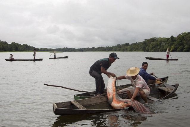
Villagers from the Porto Novo community load into their canoes arapaima or pirarucu, the largest freshwater fish species in South America and one of the largest in the world, while fishing in Poco Fundo lake along a branch of the Solimoes river, one of the main tributaries of the Amazon, in the Mamiraua nature reserve near Fonte Boa about 600 km (373 miles) west of Manaus, November 26, 2013. (Photo by Bruno Kelly/Reuters)

Villagers from the Porto Novo community load into their canoes arapaima or pirarucu, the largest freshwater fish species in South America and one of the largest in the world, while fishing in Poco Fundo lake along a branch of the Solimoes river, one of the main tributaries of the Amazon, in the Mamiraua nature reserve near Fonte Boa about 600 km (373 miles) west of Manaus, November 26, 2013. Catching the arapaima, a fish that is sought after for its meat and is considered by biologists to be a living fossil, is only allowed once a year by Brazil's environmental protection agency. The minimum size allowed for a fisherman to keep an arapaima is 1.5 meters (4.9 feet). (Photo by Bruno Kelly/Reuters)
Details
17 Dec 2013 08:03:00


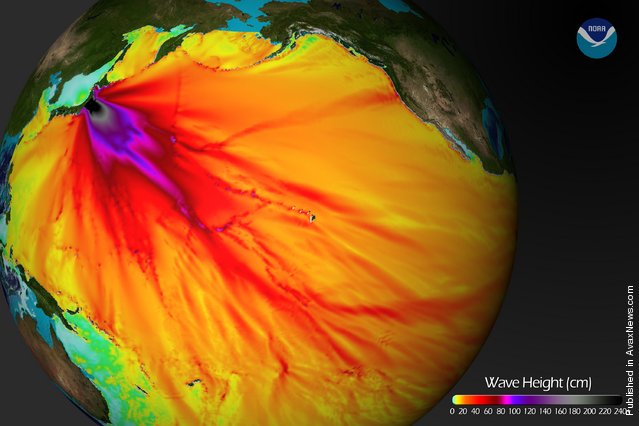
In this handout image provided by the National Oceanic and Atmospheric Administration (NOAA), model runs from the Center for Tsunami Research at the NOAA Pacific Marine Environmental Laboratory show the expected wave heights of the tsunami as it travels across the Pacific basin March 11, 2011. The largest wave heights are expected near the earthquake epicenter, off Japan. The wave will decrease in height as it travels across the deep Pacific but grow taller as it nears coastal areas. In general, as the energy of the wave decreases with distance, the near shore heights will also decrease (e.g., coastal Hawaii will not expect heights of that encountered in coastal Japan). (Photo by NOAA via Getty Images)
Details
13 Mar 2011 14:29:00
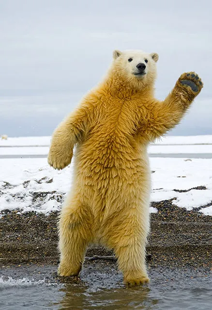
Polar Bear Photo Steven Kazlowski

The polar bear — a charismatic icon in the struggle against climate change — faces a precarious future along with other ice-dependent species as its Arctic habitat rapidly continues to melt away.

With camera in hand, wildlife photographer Steven Kazlowski has dedicated over eight years of work to bring to life the immediate reality of this most pressing environmental crisis — the devastation of the Arctic ecosystem through global warming.
Details
18 Oct 2012 10:14:00
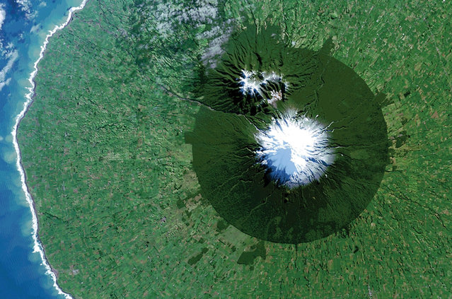
Egmont National Park in New Zealand with Mt. Taranaki at its center is seen in a Landsat 8 satellite image. (Photo by Reuters/NASA/USGS)

Egmont National Park in New Zealand with Mt. Taranaki at its center is seen in a Landsat 8 satellite image taken July 3, 2014 and released by NASA November 14, 2014. The image is from the book “Sanctuary: Exploring the World's Protected Areas from Space”, published by the Institute for Global Environmental Strategies with support from NASA, which was released this week. (Photo by Reuters/NASA/USGS)
Details
16 Nov 2014 12:15:00
Uranjargal, a leader of the Mongolian neo-Nazi group Tsagaan Khass, stands next to a statue of Chingunjav, a Mongolian national hero, in Ulan Bator June 22, 2013. (Photo by Carlos Barria/Reuters)

Uranjargal, a leader of the Mongolian neo-Nazi group Tsagaan Khass, stands next to a statue of Chingunjav, a Mongolian national hero, in Ulan Bator June 22, 2013. The group has rebranded itself as an environmentalist organisation fighting pollution by foreign-owned mines, seeking legitimacy as it sends Swastika-wearing members to check mining permits. Over the past years, ultra-nationalist groups have expanded in the country and among those garnering attention is Tsagaan Khass, which has recently shifted its focus from activities such as attacks on women it accuses of consorting with foreign men to environmental issues, with the stated goal of protecting Mongolia from foreign mining interests. This ultra-nationalist group was founded in the 1990s and currently has 100-plus members. (Photo by Carlos Barria/Reuters)
Details
09 Jul 2013 07:23:00


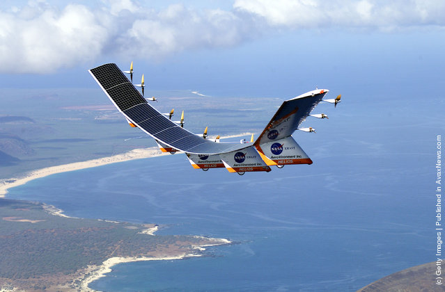
“NASA's Pathfinder, Pathfinder Plus, Centurion and Helios Prototype were an evolutionary series of solar- and fuel-cell-system-powered unmanned aerial vehicles. AeroVironment, Inc. developed the vehicles under NASA's Environmental Research Aircraft and Sensor Technology (ERAST) program. They were built to develop the technologies that would allow long-term, high-altitude aircraft to serve as “atmospheric satellites”, to perform atmospheric research tasks as well as serve as communications platforms”. – Wikipedia

Photo: The solar-electric Helios Prototype flying wing is flies over the Hawaiian islands of Niihau and Lehua during the first solar-powered test flight July 14, 2001 from the U.S. Navy's Pacific Missile Range Facility on Kauai, HI. The 18-hour flight was a functional checkout of the aircraft's systems and performance in preparation for an attempt to reach sustained flight at 100,000 feet altitude later in the summer. (Photo Courtesy of NASA/Getty Images)
Details
14 Jul 2011 09:24:00