Loading...
Done
Chernobyl

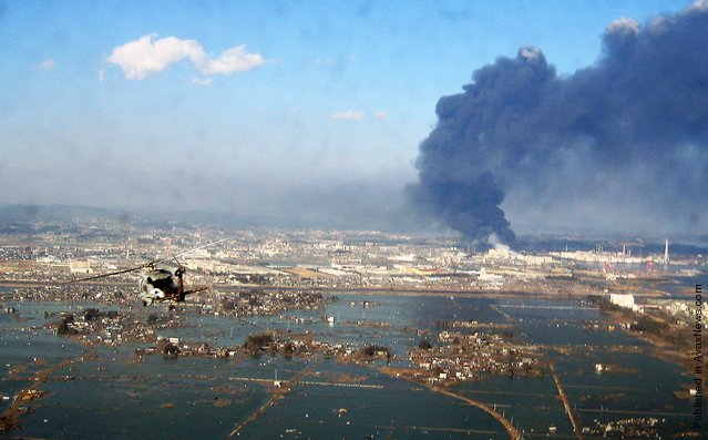
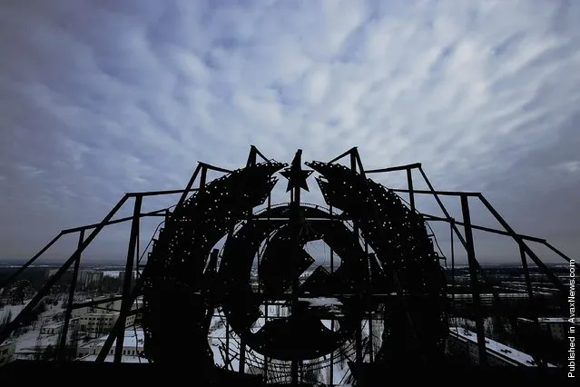
Scaffolding holding a remnant of the Soviet Union, the hammer and sickle, is seen on a rooftop of an abandoned building in the town of Pripyat on January 25, 2006 near Chernobyl, Ukraine. The town of Pripyat, deserted since the 1986 catastrophe, once housed 30,000 people, the majority of being workers from the Chernobyl Nuclear Power Plant. Days after the catastrophe the inhabitants were relocated to other locations in the Soviet Union. The town of Pripyat has remained uninhabited since. Prypyat and the surrounding area will not be safe for human habitation for several centuries. Scientists estimate that the most dangerous radioactive elements will take up to 900 years to decay sufficiently to render the area safe.
Details
14 Mar 2011 10:20:00


“With a fourth explosion rocking the Fukushima nuclear plant on Tuesday, danger of the spent nuke fuel pool boiling and radiation levels at the facility's gate increasing hundredfold, fears of a meltdown in Japan skyrocket”. – Russia Today

Photo: In this handout image provided by U.S. Navy, an aerial view of tsunami and earthquake damage is seen from an SH-60B helicopter assigned to the Chargers of Helicopter Antisubmarine Squadron (HS) 14 from Naval Air Facility Atsugi March 12, 2011 seen from the air of Sendai, Japan. (Photo by U.S. Navy via Getty Images)
Details
16 Mar 2011 10:19:00
Ender Moreno looks for gold at La Culebra gold mine in El Callao, Bolivar state, southeastern Venezuela on March 1, 2017. (Photo by Juan Barreto/AFP Photo)

Ender Moreno looks for gold at La Culebra gold mine in El Callao, Bolivar state, southeastern Venezuela on March 1, 2017. Although life in the mines of eastern Venezuela is hard and dangerous, tens of thousands from all over the country head for the mines daily in overcrowded trucks, pushed by the rise in gold prices and by the severe economic crisis affecting the country, aggravated recently by the drop in oil prices. (Photo by Juan Barreto/AFP Photo)
Details
28 Mar 2017 09:15:00
Bad Part of Town By Google Street View

Take a walk on the wild side around some of the most down right dangerous places in the world - and all without leaving your desk, courtesy of Google Street View. Since 2007, Google's amazing technology has given people the chance to visit the Eiffel Tower, peer out over San Francisco's Golden Gate Bridge or walk along a beach in the Bahamas. But as well as mapping the tourist-friendly hotspots, Google also ventured into places you really wouldn't want to find yourself. Here is a collection of some the most notorious areas captured by the infamous roaming camera cars from around the UK and the world.
Details
03 Oct 2013 11:05:00
A woman is supported by two men while crossing a river, north of Idomeni, Greece, as migrants attempt to reach Macedonia on a route that would bypass the border fence, Monday, March 14, 2016. (Photo by Vadim Ghirda/AP Photo)

A woman is supported by two men while crossing a river, north of Idomeni, Greece, as migrants attempt to reach Macedonia on a route that would bypass the border fence, Monday, March 14, 2016. Hundreds of migrants and refugees walked out of an overcrowded camp on the Greek-Macedonian border Monday, determined to use a dangerous crossing to head north. (Photo by Vadim Ghirda/AP Photo)
Details
15 Mar 2016 14:08:00
A storm whips through a tented area occupied by Nepalese earthquake survivors as a mother grabs her infant child and runs to find shelter in Kathmandu, Nepal 23 May 2015. Nepalese, who lost their homes in earthquake and fear aftershocks, have been living in temporary shelter in open ground which they had to flee because of the heavy rain and powerful wind. (Photo by Narendra Shrestha/EPA)

A storm whips through a tented area occupied by Nepalese earthquake survivors as a mother grabs her infant child and runs to find shelter in Kathmandu, Nepal 23 May 2015. Nepalese, who lost their homes in earthquake and fear aftershocks, have been living in temporary shelter in open ground which they had to flee because of the heavy rain and powerful wind. (Photo by Narendra Shrestha/EPA)
Details
25 May 2015 10:00:00
An Emirati child plays with an airplane model near the venue of the Mazayin Dhafra Camel Festival, on December 20, 2012 near the city of Madinat Zayed, 150 kms west of Abu Dhabi. The festival, which attracts participants from around the Gulf region, includes a camel beauty contest, a display of UAE handcrafts and other activities aimed at promoting the country's folklore. (Photo by Karim Sahib/AFP Photo)

An Emirati child plays with an airplane model near the venue of the Mazayin Dhafra Camel Festival, on December 20, 2012 near the city of Madinat Zayed, 150 kms west of Abu Dhabi. The festival, which attracts participants from around the Gulf region, includes a camel beauty contest, a display of UAE handcrafts and other activities aimed at promoting the country's folklore. (Photo by Karim Sahib/AFP Photo)
Details
09 Sep 2015 13:09:00
In this photograph taken on April 1, 2015, an Indonesian resident and child walk away from an abandoned school building as Mount Sinabung erupts in Karo district on the Indonesian island of Sumatra. According to authorities about 3,500 people were displaced after the February 2014 eruption of Mount Sinabung volcano and many are still living in evacuation centers as the volcano remains active. (Photo by Sutanta Aditya/AFP Photo)

In this photograph taken on April 1, 2015, an Indonesian resident and child walk away from an abandoned school building as Mount Sinabung erupts in Karo district on the Indonesian island of Sumatra. According to authorities about 3,500 people were displaced after the February 2014 eruption of Mount Sinabung volcano and many are still living in evacuation centers as the volcano remains active. (Photo by Sutanta Aditya/AFP Photo)
Details
04 Apr 2015 10:32:00