Loading...
Done
People struggle with the wind as they cross the street under the rain as typhoon Mitag is expected to hit northern Taiwan, in Keelung, Taiwan, 30 September 2019. According to report, Typhoon Mitag will disrupt air, land and water traffic. Mitag is located at sea about 290 kilometers off the south-southeast of Yilan County, moving at 27 kilometers per hour at a northwesterly direction, with maximum sustained winds of 126 kilometers per hour, with gusts of up to 162 kilometers per hour, and with a radius of 180 kilometers, according to Taiwan Central Weather Bureau. (Photo by Ritchie B. Tongo/EPA/EFE/Rex Features/Shutterstock)

People struggle with the wind as they cross the street under the rain as typhoon Mitag is expected to hit northern Taiwan, in Keelung, Taiwan, 30 September 2019. According to report, Typhoon Mitag will disrupt air, land and water traffic. Mitag is located at sea about 290 kilometers off the south-southeast of Yilan County, moving at 27 kilometers per hour at a northwesterly direction, with maximum sustained winds of 126 kilometers per hour, with gusts of up to 162 kilometers per hour, and with a radius of 180 kilometers, according to Taiwan Central Weather Bureau. (Photo by Ritchie B. Tongo/EPA/EFE/Rex Features/Shutterstock)
Details
02 Oct 2019 00:05:00
A cosplayer portrays Himiko Toga from “League of Villains” outside the convention center during Comic-Con International 2022 on July 22, 2022 in San Diego, California. (Photo by Robyn Beck/AFP Photo)

A cosplayer portrays Himiko Toga from “League of Villains” outside the convention center during Comic-Con International 2022 on July 22, 2022 in San Diego, California. (Photo by Robyn Beck/AFP Photo)
Details
03 Aug 2022 04:48:00
Longsheng Rice Terraces

The Longsheng Rice Terraces are located in Longsheng County, about 100 km (2 hours drive) from Guilin, Guangxi, China. The most popular are Ping An Rice Terrace and Jinkeng Rice Terrace. The terraced fields are built along the slope winding from the riverside up to the mountain top, the highest part being 880 m in elevation while the lowest part is 380 m[citation needed]. The coiling line that starts from the mountain foot up to the mountain top divides the mountain into layers of water glittering in the sun in spring, layers of green rice shoots in summer, layers of golden rice in fall, and layers of silvery frost in winter. The terraced fields were mostly built during the Ming Dynasty, about 500 years ago.
Details
18 Oct 2013 12:45:00
A woman walks past as South Korean soldiers participate in an anti-chemical and anti-terror exercise as part of the 2023 Ulchi Freedom Shield (UFS) at subway station on August 22, 2023 in Seoul, South Korea. The 11-day exercise, which features drills including the handling of chemical and biological attacks, is a regular joint exercise between U.S. and South Korean troops. The exercise serves as a platform for the South Korean government to prepare for potential emergencies on the Korean Peninsula, with some 580,000 officials from about 4,000 city, county and ward governments, public institutions and others across the nation participating. (Photo by Chung Sung-Jun/Getty Images)

A woman walks past as South Korean soldiers participate in an anti-chemical and anti-terror exercise as part of the 2023 Ulchi Freedom Shield (UFS) at subway station on August 22, 2023 in Seoul, South Korea. The 11-day exercise, which features drills including the handling of chemical and biological attacks, is a regular joint exercise between U.S. and South Korean troops. (Photo by Chung Sung-Jun/Getty Images)
Details
26 Aug 2023 02:53:00
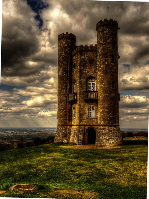
Broadway Tower In English

Broadway Tower is a folly located on Broadway Hill, near the village of Broadway, in the English county of Worcestershire, at the second highest point of the Cotswolds after Cleeve Hill. Broadway Tower's base is 1,024 feet (312 metres) above sea level. The tower itself stands 55 feet (17 metres) high. The “Saxon” tower was designed by James Wyatt in 1794 in the form of a castle, and built for Lady Coventry in 1799. The tower was built on a “beacon” hill, where beacons were lit on special occasions. Lady Coventry wondered if a beacon on this hill could be seen from her house in Worcester – approximately 22 miles (35 km) away – and sponsored the construction of the folly to find out. The beacon could be seen clearly.
Details
19 Dec 2013 10:06:00
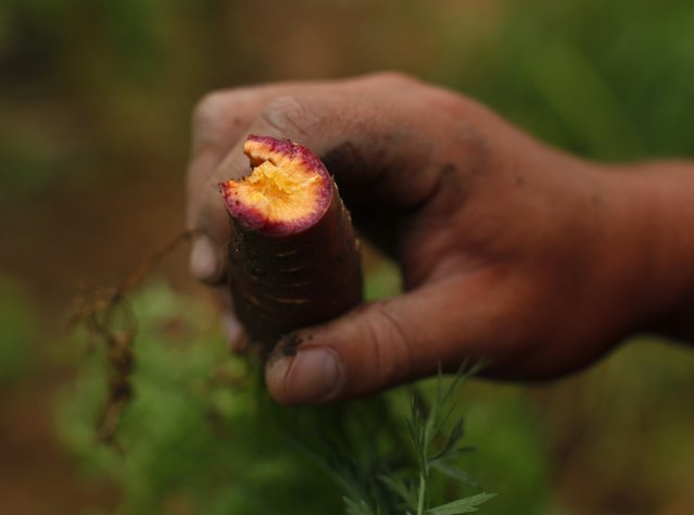
Makoto Chino eats a purple haze carrot as he works harvesting the morning's vegetables and fruit from his family's farm in Rancho Santa Fe, California August 12, 2014. (Photo by Mike Blake/Reuters)

Makoto Chino eats a purple haze carrot as he works harvesting the morning's vegetables and fruit from his family's farm in Rancho Santa Fe, California August 12, 2014. The gravitational pull of Chino Farm is legendary. Since they don't ship, everyone – whether a top chef or a traveling foodie or a local resident – comes to the farm stand, simply called “Vegetable Shop”, on a dusty corner of this affluent San Diego County town, hemmed in by sprawling housing estates. (Photo by Mike Blake/Reuters)
Details
26 Nov 2014 14:41:00


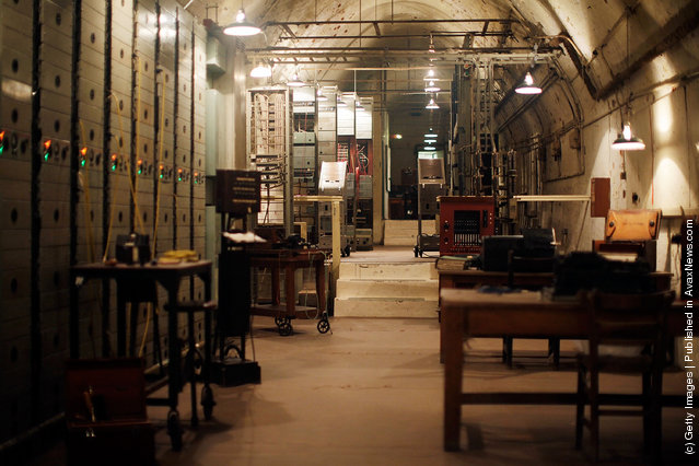
“Dover Castle is a medieval castle in the town of the same name in the English county of Kent. It was founded in the 12th century and has been described as the “Key to England” due to its defensive significance throughout history. It is the largest castle in England.

The outbreak of the Second World War in 1939 saw the tunnels converted first into an air-raid shelter and then later into a military command centre and underground hospital. In May 1940, Admiral Sir Bertram Ramsey directed the evacuation of French and British soldiers from Dunkirk, code-named Operation Dynamo, from his headquarters in the cliff tunnels”. – Wikipedia

Photo: The Repeater Station in the subterranean tunnels underneath Dover Castle, which has been restored by English Heritage for a public exhibition on June 3, 2011 in Dover, England. The evacuation of allied soldiers from Dunkirk was masterminded and co-ordinated from the secret command and control centre in the tunnels deep below the castle. (Photo by Matthew Lloyd/Getty Images)
Details
07 Jun 2011 09:26:00
A woman combs her hair at the Huangluo Village of the Yao ethnic group in Guilin, south China's Guangxi Zhuang Autonomous Region, July 15, 2012. (Photo by Lu Boan/Xinhua)

“The Yao nationality is a government classification for various minorities in China. They form one of the 55 ethnic minority groups officially recognized by the People's Republic of China, where they reside in the mountainous terrain of the southwest and south”. – Wikipedia

Photo: A woman combs her hair at the Huangluo Village of the Yao ethnic group in Guilin, south China's Guangxi Zhuang Autonomous Region, July 15, 2012. The Huangluo Village of the Yao ethnic group locates at the Longji Terraces in Heping Town of Longsheng County in Guilin. Women here have the tradition of keeping long hair. They believe that long hair brings good luck and fortune. The average length of hair of 180 women in the village is 1.7 meters. (Photo by Lu Boan/Xinhua)
Details
07 Mar 2015 08:33:00