Done
Jensen a two-year-old False Map turtle, from the Mississippi River, gets used to his new home at Blackpool Sea Life Centre

Jensen a two-year-old False Map turtle, from the Mississippi River, gets used to his new home at Blackpool Sea Life Centre on February 13, 2012 in Blackpool, England. (Photo by Christopher Furlong/Getty Images)
Details
13 Feb 2012 12:36:00
Google Street View Captures Donkey Accident

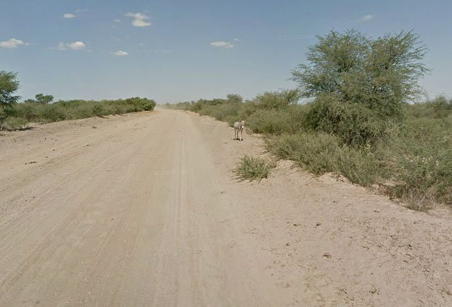
When Google Maps was capturing images of a Street View in Botswana, it appeared that this donkey had been hit by a car. However, a representative from Google Maps has confirmed that the donkey was merely enjoying a roll in the dirt and is alive and well.
Details
20 Jan 2013 12:29:00
Humanoid robot bartender “Carl” interacts with guests at the Robots Bar and Lounge in the eastern German town of Ilmenau, July 26, 2013. “Carl”, developed and built by mechatronics engineer Ben Schaefer who runs a company for humanoid robots, prepares spirits for the mixing of cocktails and is able to interact with customers in small conversations. (Photo by Fabrizio Bensch/Reuters)

Humanoid robot bartender “Carl” interacts with guests at the Robots Bar and Lounge in the eastern German town of Ilmenau, July 26, 2013. “Carl”, developed and built by mechatronics engineer Ben Schaefer who runs a company for humanoid robots, prepares spirits for the mixing of cocktails and is able to interact with customers in small conversations. (Photo by Fabrizio Bensch/Reuters)
Details
22 Oct 2013 09:04:00
Spot-billed pelican interact on the banks of an artificial lake in Colombo on September 28, 2021. (Photo by Ishara S. Kodikara/AFP Photo)

Spot-billed pelican interact on the banks of an artificial lake in Colombo on September 28, 2021. (Photo by Ishara S. Kodikara/AFP Photo)
Details
11 Nov 2021 08:34:00
A fruit bat eats lettuce as it hangs from a rope during a behind the scenes interactive live stream from the Oakland Zoo on April 16, 2020 in Oakland, California. Since the Oakland Zoo has been closed to the public during the shelter in place, they are offering a subscription based service that will feature five weekly behind the scenes live streamed interactive programs that will feature animal keepers and their animals. Viewers are able to interact with the keepers by submitting questions to about the animals. (Photo by Justin Sullivan/Getty Images)

A fruit bat eats lettuce as it hangs from a rope during a behind the scenes interactive live stream from the Oakland Zoo on April 16, 2020 in Oakland, California. Since the Oakland Zoo has been closed to the public during the shelter in place, they are offering a subscription based service that will feature five weekly behind the scenes live streamed interactive programs that will feature animal keepers and their animals. Viewers are able to interact with the keepers by submitting questions to about the animals. (Photo by Justin Sullivan/Getty Images)
Details
19 Apr 2020 00:05:00
Women take part in the desert trek “Rose Trip Maroc”, on November 1, 2019 in the erg Chebbi near Merzouga. The Rose Trip Maroc is a female-oriented trek where teams of three must travel through the southern Moroccan Sahara desert with a compass, a map and a topographical reporter. (Photo by Jean-Philippe Ksiazek/AFP Photo)

Women take part in the desert trek “Rose Trip Maroc”, on November 1, 2019 in the erg Chebbi near Merzouga. The Rose Trip Maroc is a female-oriented trek where teams of three must travel through the southern Moroccan Sahara desert with a compass, a map and a topographical reporter. (Photo by Jean-Philippe Ksiazek/AFP Photo)
Details
04 Nov 2019 00:01:00
From Britain to China to Mali, new maps showing travel times to the nearest urban centre reveal huge differences between countries. Using Open Street Map and Google, a University of Oxford team have created a visual breakdown that suggests major inequalities when it comes to commuting. Here: China. The dataset used for China was unique as it relied solely on Open Street Map, due to restrictions on accessing Google data. The population is densely concentrated in the east and accessibility is increased, whereas rural provinces in the west remain remote. (Photo by Daniel Weiss/Jennifer Rozier/Malaria Atlas Project/University of Oxford )

From Britain to China to Mali, new maps showing travel times to the nearest urban centre reveal huge differences between countries. Using Open Street Map and Google, a University of Oxford team have created a visual breakdown that suggests major inequalities when it comes to commuting. Here: China. The dataset used for China was unique as it relied solely on Open Street Map, due to restrictions on accessing Google data. The population is densely concentrated in the east and accessibility is increased, whereas rural provinces in the west remain remote. (Photo by Daniel Weiss/Jennifer Rozier/Malaria Atlas Project/University of Oxford)
Details
12 Jan 2018 06:43:00
Penguins Momo and Omochi are seen while the projection mapping images is being cast during a media preview for their free online animal shows for children and families staying at home during Golden Week holidays due to the coronavirus disease (COVID-19) lockdown, at the Aqua Park Shinagawa in Tokyo, Japan on April 30, 2020. (Photo by Issei Kato/Reuters)

Penguins Momo and Omochi are seen while the projection mapping images is being cast during a media preview for their free online animal shows for children and families staying at home during Golden Week holidays due to the coronavirus disease (COVID-19) lockdown, at the Aqua Park Shinagawa in Tokyo, Japan on April 30, 2020. (Photo by Issei Kato/Reuters)
Details
11 May 2020 00:01:00