Loading...
Done


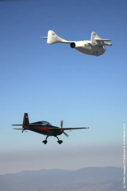
“SpaceShipOne was a suborbital air-launched spaceplane that completed the first manned private spaceflight in 2004. That same year, it won the US$10 million Ansari X Prize and was immediately retired from active service. Its mothership was named “White Knight”. Both craft were developed and flown by Mojave Aerospace Ventures, which was a joint venture between Paul Allen and Scaled Composites, Burt Rutan's aviation company. Allen provided the funding of approximately US$25 million”. – Wikipedia

Photo: A chase plane follows SpaceShipOne after it reached a height of 62 miles in the first non-governmental flight to leave the Earth's atmosphere on June 21, 2004 in Mojave, California. SpaceShipOne spacecraft was carried to a height of 50,000 by the twin-turbojet high-altitude research aircraft, “White Knight”, where it was launched for its final climb. The space effort was funded by Microsoft co-founder Paul Allen and headed by aerospace engineer Burt Rutan. (Photo by Jim Campbell-Pool/Getty Images)
Details
26 Jun 2011 09:56:00
In this file photo taken on Sunday, August 2, 2020, Sviatlana Tsikhanouskaya, candidate for the presidential elections greets people waving old Belarus flags during a meeting to show her support, in Brest, 326 km (203,7 miles) southwest of Minsk, Belarus. Belarus’ authoritarian President Alexander  Lukashenko faces a perfect storm as he seeks a sixth term in the election held Sunday, Aug. 9, 2020 after 26 years in office. Mounting public discontent over the worsening economy and his government’s bungled handling of the coronavirus pandemic has fueled the largest opposition rallies since the Soviet collapse. (Photo by Sergei Grits/AP Photo)

In this file photo taken on Sunday, August 2, 2020, Sviatlana Tsikhanouskaya, candidate for the presidential elections greets people waving old Belarus flags during a meeting to show her support, in Brest, 326 km (203,7 miles) southwest of Minsk, Belarus. Belarus’ authoritarian President Alexander Lukashenko faces a perfect storm as he seeks a sixth term in the election held Sunday, Aug. 9, 2020 after 26 years in office. Mounting public discontent over the worsening economy and his government’s bungled handling of the coronavirus pandemic has fueled the largest opposition rallies since the Soviet collapse. (Photo by Sergei Grits/AP Photo)
Details
10 Aug 2020 00:01:00
The carcass of a yacare caiman lies in the dried-up river bed of the Pilcomayo river in Boqueron, Paraguay, August 14, 2016. In Paraguay, alongside the Pilcomayo River, black vultures flew over a shrinking pond where a group of crocodilian reptiles known as yacare caimans sought refuge. Water from the river, which divides Paraguay and Argentina in the area of the Gran Chaco, was scarce. This is not an uncommon sight in the region of General Diaz, about 700 kilometres (435 miles) northwest of the country's capital Asuncion, where the Pilcomayo's waters form lakes and streams that give life to capybaras, birds and caimans. “The river's situation is critical. No water is forecast to enter the basin until December, as happens every year”, said Alcides Gonzalez, a resident of the area. (Photo by Jorge Adorno/Reuters)

The carcass of a yacare caiman lies in the dried-up river bed of the Pilcomayo river in Boqueron, Paraguay, August 14, 2016. In Paraguay, alongside the Pilcomayo River, black vultures flew over a shrinking pond where a group of crocodilian reptiles known as yacare caimans sought refuge. Water from the river, which divides Paraguay and Argentina in the area of the Gran Chaco, was scarce. This is not an uncommon sight in the region of General Diaz, about 700 kilometres (435 miles) northwest of the country's capital Asuncion, where the Pilcomayo's waters form lakes and streams that give life to capybaras, birds and caimans. (Photo by Jorge Adorno/Reuters)
Details
03 Nov 2016 12:40:00
In this photo taken Thursday, May 7, 2015 photo,  remains of Soviet soldiers killed during World War II lay in a coffin prior to a reburial ceremony at the Sinyavino Heights memorial near the village of Sinyavino, 50 km (31 miles) east of  St. Petersburg, Russia. Hundreds of people came to a World War II battleground outside St. Petersburg this week to bury the remains of 964 Soviet soldiers recovered by volunteer search teams. (Photo by Dmitry Lovetsky/AP Photo)

In this photo taken Thursday, May 7, 2015 photo, remains of Soviet soldiers killed during World War II lay in a coffin prior to a reburial ceremony at the Sinyavino Heights memorial near the village of Sinyavino, 50 km (31 miles) east of St. Petersburg, Russia. Hundreds of people came to a World War II battleground outside St. Petersburg this week to bury the remains of 964 Soviet soldiers recovered by volunteer search teams. Fifty crimson coffins containing skulls and bones were solemnly buried at the Sinyavino Heights memorial as Russian war songs played and an honor guard fired a salute. (Photo by Dmitry Lovetsky/AP Photo)
Details
10 May 2015 11:12:00
The eruption of Cordon Caulle began on June 4, 2011, located in the Region of Los Rios in Chile. For about 12 months, people and animals became accustomed to living with the daily fall of ash, which also caused problems in the air traffic in South America. The explosions and lightning during first days of the eruption could be seen from hundreds of miles around. This photograph was taken on the second night of eruption from the town of Lago Ranco. (Photo and caption by Francisco Negroni/National Geographic Traveler Photo Contest)

The eruption of Cordon Caulle began on June 4, 2011, located in the Region of Los Rios in Chile. For about 12 months, people and animals became accustomed to living with the daily fall of ash, which also caused problems in the air traffic in South America. The explosions and lightning during first days of the eruption could be seen from hundreds of miles around. This photograph was taken on the second night of eruption from the town of Lago Ranco. (Photo and caption by Francisco Negroni/National Geographic Traveler Photo Contest)

ATTENTION! All pictures are presented in high resolution. To see Hi-Res images – just TWICE click on any picture. In other words, click small picture – opens the BIG picture. Click BIG picture – opens VERY BIG picture.
Details
23 Jun 2013 11:24:00
This handout photo taken and released on August 1, 2025 by Indonesia's Geological Agency shows Mount Lewotobi Laki-Laki spewing lava and volcanic ash up to approximately 10 kilometres high during its eruption as observed from the monitoring post in East Flores, in East Nusa Tenggara province. A volcano in eastern Indonesia erupted on August 1, belching an ash tower 10 kilometres (6.2 miles) into the sky, the country's volcanology agency said, weeks after another huge eruption triggered dozens of flight cancellations to and from Bali. (Photo by Indonesia's Geological Agency/AFP Photo)

This handout photo taken and released on August 1, 2025 by Indonesia's Geological Agency shows Mount Lewotobi Laki-Laki spewing lava and volcanic ash up to approximately 10 kilometres high during its eruption as observed from the monitoring post in East Flores, in East Nusa Tenggara province. A volcano in eastern Indonesia erupted on August 1, belching an ash tower 10 kilometres (6.2 miles) into the sky, the country's volcanology agency said, weeks after another huge eruption triggered dozens of flight cancellations to and from Bali. (Photo by Indonesia's Geological Agency/AFP Photo)

Details
24 Nov 2025 04:52:00
Snow Wall in Japan

The Tateyama Kurobe Alpine Route is an international mountain sightseeing route some 90 kilometers (56 miles) long. The route goes across the 3,000-meter-high North Alpine mountains, the so-called “roof of Japan,” and connects Toyama and Shinano Omachi. You can enjoy the panorama by taking a train, highland bus, trolley bus, cable car, and ropeway. Since the lines opened in June 1971, the Tateyama mountain area has been transformed from an isolated spot into one of the nation’s best sightseeing areas, where a million guests visit every year.
Details
27 Jul 2012 09:28:00
Visitors walk on the Giant's Causway in Portrush, Northern Ireland

“The Giant's Causeway is an area of about 40,000 interlocking basalt columns, the result of an ancient volcanic eruption. It is located in County Antrim on the northeast coast of Northern Ireland, about three miles (4.8 km) northeast of the town of Bushmills. It was declared a World Heritage Site by UNESCO in 1986, and a National Nature Reserve in 1987 by the Department of the Environment for Northern Ireland”. – Wikipedia

Photo: Visitors walk on the Giant's Causway on March 14, 2012 in Portrush, Northern Ireland. (Photo by Peter Macdiarmid/Getty Images)
Details
17 Mar 2012 11:10:00