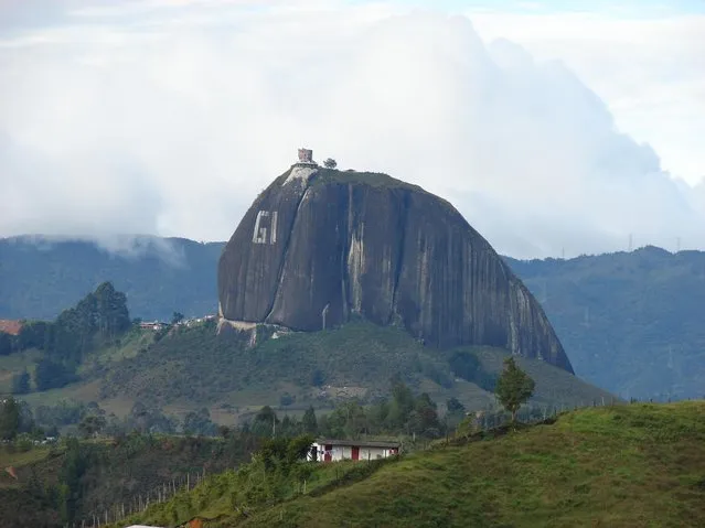
Loading...
Done
Avenue of the Baobabs

The Avenue or Alley of the Baobabs is a prominent group of baobab trees lining the dirt road between Morondava and Belon'i Tsiribihina in the Menabe region in western Madagascar. Its striking landscape draws travelers from around the world, making it one of the most visited locations in the region. It has been a center of local conservation efforts, and was granted temporary protected status in July 2007 by the Ministry of Environment, Water and Forests, the first step toward making it Madagascar's first natural monument.
Details
16 Nov 2012 10:05:00
Mandarin Fish

The Mandarinfish or Mandarin dragonet (Synchiropus splendidus), is a small, brightly-colored member of the dragonet family, which is popular in the saltwater aquarium trade. The mandarinfish is native to the Pacific, ranging approximately from the Ryukyu Islands south to Australia.
Details
27 Nov 2012 10:02:00
Sri Lanka

Sri Lanka officially the Democratic Socialist Republic of Sri Lanka, is an island country in the northern Indian Ocean off the southern coast of the Indian subcontinent in South Asia. Known until 1972 as Ceylon Sri Lanka has maritime borders with India to the northwest and the Maldives to the southwest.
Details
24 Aug 2013 08:59:00
Oresund Bridge

The Öresund or Øresund Bridge is a double-track railway and dual carriageway bridge-tunnel across the Øresund strait between Scania (southernmost Sweden) and Denmark. The bridge runs nearly 8 km (5 miles) from the Swedish coast to the artificial island of Peberholm, which lies in the middle of the strait. The remainder of the link is by a 4 km (2.5 mile) tunnel from Peberholm to the Danish island of Amager. The Øresund Bridge is the longest combined road and rail bridge in Europe, and connects two major metropolitan areas: Copenhagen, the Danish capital city, and the major Swedish city of Malmö. It connects the road and rail networks of Scandinavia with those of Central and Western Europe.
Details
10 Sep 2013 11:23:00
Moraine Lake Canada

Moraine Lake is a glacially-fed lake in Banff National Park, 14 kilometres (8.7 mi) outside the Village of Lake Louise, Alberta, Canada. It is situated in the Valley of the Ten Peaks, at an elevation of approximately 6,183 feet (1,885 m). The lake has a surface area of .5 square kilometres (0.19 sq mi). The lake, being glacially fed, does not reach its crest until mid to late June. When it is full, it reflects a distinct shade of blue. The colour is due to the refraction of light off the rock flour deposited in the lake on a continual basis.
Details
15 Oct 2013 11:56:00
Buddhist Monastery Key Gompa

Key Gompa (also spelled Ki, Kye or Kee) is a Tibetan Buddhist monastery located on top of a hill at an altitude of 4,166 metres (13,668 ft) above sea level, close to the Spiti River, in the Spiti Valley of Himachal Pradesh, Lahaul and Spiti district, India. It is the biggest monastery of Spiti Valley and a religious training centre for Lamas. It reportedly had 100 monks in 1855.
Details
05 Dec 2013 10:48:00
Broadway Tower In English

Broadway Tower is a folly located on Broadway Hill, near the village of Broadway, in the English county of Worcestershire, at the second highest point of the Cotswolds after Cleeve Hill. Broadway Tower's base is 1,024 feet (312 metres) above sea level. The tower itself stands 55 feet (17 metres) high. The “Saxon” tower was designed by James Wyatt in 1794 in the form of a castle, and built for Lady Coventry in 1799. The tower was built on a “beacon” hill, where beacons were lit on special occasions. Lady Coventry wondered if a beacon on this hill could be seen from her house in Worcester – approximately 22 miles (35 km) away – and sponsored the construction of the folly to find out. The beacon could be seen clearly.
Details
19 Dec 2013 10:06:00
Dive The Deadly Jacob’s Well In Texas

Jacob's Well is a perennial karstic spring in the Texas Hill Country flowing from the bed of Cypress Creek, located northwest of Wimberley, Texas. The twelve foot (four meter) diameter mouth of the spring serves as a popular swimming spot for the local land owners whose properties adjoin Cypress Creek. From the opening in the creek bed, Jacob's Well cave descends vertically for about thirty feet (ten meters), then continues downward at an angle through a series of silted chambers separated by narrow restrictions, finally reaching a depth of one hundred and twenty feet (forty meters). Until the modern era, the Trinity Aquifer-fed natural artesian spring gushed water from the mouth of the cave, with a measured flow in 1924 of one hundred and seventy gallons per second (six hundred and forty liters per second) discharging six feet (two meters) into the air. The spring is the greatest source of water recharging the Edwards Aquifer.
Details
03 Jan 2014 08:20:00