Loading...
Done
January 2013. A scene in Yakutsk, Siberia, the coldest city in the world. (Photo by Steeve Iuncker/Agence VU)

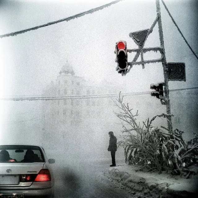
Yakutsk, a remote city in Eastern Siberia along the Lena River, is the coldest city in the world. Located 1840 km away from Irkoustk and 5000 km away from Moscow, this city founded in 1632 by the Cossacks imposes upon its inhabitants an extreme way of life. And yet, despite particularly harsh conditions, Yakutsk boasts a population of 270,000, or a quarter of the entire population of Siberia. No other place on the planet experiences the temperature extreme found here: in winter, the temperatures regularly fall to minus 40° (the coldest temperature recorded was –64°C) and in summer often reaches temperatures above 30°C. Photo: January 2013. A scene in Yakutsk, Siberia, the coldest city in the world. (Photo by Steeve Iuncker/Agence VU)
Details
29 Apr 2013 10:30:00
A dog sits in the shade of a mangrove tree as a woman uses a fork to dig for shellfish on the reef-mud flats of a lagoon located at South Tarawa in the central Pacific island nation of Kiribati May 23, 2013. (Photo by David Gray/Reuters)

A dog sits in the shade of a mangrove tree as a woman uses a fork to dig for shellfish on the reef-mud flats of a lagoon located at South Tarawa in the central Pacific island nation of Kiribati May 23, 2013. Kiribati consists of a chain of 33 atolls and islands that stand just metres above sea level, spread over a huge expanse of otherwise empty ocean. With surrounding sea levels rising, Kiribati President Anote Tong has predicted his country will likely become uninhabitable in 30-60 years because of inundation and contamination of its freshwater supplies. (Photo by David Gray/Reuters)
Details
13 Jun 2013 09:23:00
Water is seen on part of the glacial ice sheet that covers about 80 percent of the country is seen on July 17, 2013 on the Glacial Ice Sheet, Greenland. (Photo by Joe Raedle/Getty Images via The Atlantic)

Water is seen on part of the glacial ice sheet that covers about 80 percent of the country is seen on July 17, 2013 on the Glacial Ice Sheet, Greenland. As the sea levels around the globe rise, researchers affilitated with the National Science Foundation and other organizations are studying the phenomena of the melting glaciers and its long-term ramifications. The warmer temperatures that have had an effect on the glaciers in Greenland also have altered the ways in which the local populace farm, fish, hunt and even travel across land. In recent years, sea level rise in places such as Miami Beach has led to increased street flooding and prompted leaders such as New York City Mayor Michael Bloomberg to propose a $19.5 billion plan to boost the citys capacity to withstand future extreme weather events by, among other things, devising mechanisms to withstand flooding. (Photo by Joe Raedle)
Details
02 Aug 2013 10:51:00
Villagers from the Porto Novo community load into their canoes arapaima or pirarucu, the largest freshwater fish species in South America and one of the largest in the world, while fishing in Poco Fundo lake along a branch of the Solimoes river, one of the main tributaries of the Amazon, in the Mamiraua nature reserve near Fonte Boa about 600 km (373 miles) west of Manaus, November 26, 2013. (Photo by Bruno Kelly/Reuters)

Villagers from the Porto Novo community load into their canoes arapaima or pirarucu, the largest freshwater fish species in South America and one of the largest in the world, while fishing in Poco Fundo lake along a branch of the Solimoes river, one of the main tributaries of the Amazon, in the Mamiraua nature reserve near Fonte Boa about 600 km (373 miles) west of Manaus, November 26, 2013. Catching the arapaima, a fish that is sought after for its meat and is considered by biologists to be a living fossil, is only allowed once a year by Brazil's environmental protection agency. The minimum size allowed for a fisherman to keep an arapaima is 1.5 meters (4.9 feet). (Photo by Bruno Kelly/Reuters)
Details
17 Dec 2013 08:03:00
Eli Martinez with hammerhead shark. (Photo by J. P. Zegarra/Caters News)

“This is the terrifying moment a diver came head to head with a shark as it swims inches away snatching a bite for dinner. The close encounter, captured off Bimini Island in the Bahamas, shows the hammerhead approaching diver Eli Martinez who bravely stands his ground as the giant beast approaches. Eli, free diving outside of a protective cage, carefully handled the sea creature despite its menacing razor-sharp teeth – but admitted they are extremely shy and need a lot of work to allow divers close to them. After multiple trips and hours of diving nearby they finally got used to Eli in January this year – hammerheads regularly visit these waters during the winter season”. – Caters News. Photo: Eli Martinez with hammerhead shark. (Photo by J. P. Zegarra/Caters News)
Details
11 Mar 2014 09:24:00
The container ship MSC Fabiola (R) is seen docked at the Port of Oakland on March 22, 2012, in Oakland, California

“MSC Fabiola is a container ship owned by Mediterranean Shipping Company (MSC), the largest such vessel ever to dock in North America. In March 2012 the ship shifted from its initial Asia-to-Europe service to begin trans-Pacific service. On March 19, 2012, Fabiola docked at the Port of Long Beach, breaking earlier records for the largest container ship at a US port, and at any North American port”. – Wikipedia

Photo: The container ship MSC Fabiola (R) is seen docked at the Port of Oakland on March 22, 2012, in Oakland, California. The MSC Fabiola is the largest container ship ever to dock at any seaport in North America with an overall length of nearly one quarter mile long. (Photo by Justin Sullivan/Getty Images)
Details
23 Mar 2012 11:18:00


“The Berlin Wall (German: Berliner Mauer) was a barrier constructed by the German Democratic Republic (GDR, East Germany) starting on 13 August 1961, that completely cut off West Berlin from surrounding East Germany and from East Berlin. The barrier included guard towers placed along large concrete walls, which circumscribed a wide area (later known as the “death strip”) that contained anti-vehicle trenches, “fakir beds” and other defenses. The Soviet-dominated Eastern Bloc officially claimed that the wall was erected to protect its population from fascist elements conspiring to prevent the “will of the people” in building a socialist state in East Germany. However, in practice, the Wall served to prevent the massive emigration and defection that marked Germany and the communist Eastern Bloc during the post-World War II period”. – Wikipedia

Photo: West Berlin policemen and East German Volkspolizei face each other across the border in Berlin, circa 1955. (Photo by Three Lions/Hulton Archive/Getty Images)
Details
22 May 2011 10:49:00


“Dover Castle is a medieval castle in the town of the same name in the English county of Kent. It was founded in the 12th century and has been described as the “Key to England” due to its defensive significance throughout history. It is the largest castle in England.

The outbreak of the Second World War in 1939 saw the tunnels converted first into an air-raid shelter and then later into a military command centre and underground hospital. In May 1940, Admiral Sir Bertram Ramsey directed the evacuation of French and British soldiers from Dunkirk, code-named Operation Dynamo, from his headquarters in the cliff tunnels”. – Wikipedia

Photo: The Repeater Station in the subterranean tunnels underneath Dover Castle, which has been restored by English Heritage for a public exhibition on June 3, 2011 in Dover, England. The evacuation of allied soldiers from Dunkirk was masterminded and co-ordinated from the secret command and control centre in the tunnels deep below the castle. (Photo by Matthew Lloyd/Getty Images)
Details
07 Jun 2011 09:26:00