Loading...
Done
Pine trees are seen after a forest fire near Sao Pedro do Sul, Portugal August 14, 2016. (Photo by Rafael Marchante/Reuters)

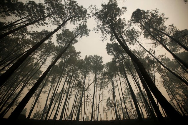
Pine trees are seen after a forest fire near Sao Pedro do Sul, Portugal August 14, 2016. Deadly wildfires raging for two weeks in Portugal have destroyed a wooded area the size of 100,000 soccer fields, and the small Iberian nation alone accounts for half of all forests burned in the European Union this year. (Photo by Rafael Marchante/Reuters)
Details
17 Aug 2016 11:07:00
1941 Chevrolet 1.5 tonnes are left to rot in a field. (Photo by Robert Kahl/Mediadrumworld)

Feast your eyes on Europe’s most spectacular car graveyards as discovered by one auto-obsessed explorer who has dedicated over ten years to finding the best cars left to rot in the European wilderness. The beautiful set of images were taken in Germany, Sweden and Belgium by German Civil Servant Robert Kahl (30) using a Nikon D7100. He describes his photographs as showcasing “the beauty of transience and decayed charm”. Here: 1941 Chevrolet 1.5 tonnes are left to rot in a field. (Photo by Robert Kahl/Mediadrumworld)
Details
01 Mar 2017 00:04:00


Head of European Prints, Severine Nackers holds a celestial Map of the Southern Sky by Albrecht Durer, at Sotheby's Auction House on March 25, 2011 in London, England. The two woodcut maps depicting the Northern and Southern skies circa 1515, are the earliest printed star charts of their kind ever published in Europe, and are expected to fetch between Ј120,000-180,000 GBP when they go on sale at the “London sale of Old Master, Modern and Contemporary prints” at Sotheby's Auction house on March 30, 2011. (Photo by Dan Kitwood/Getty Images)
Details
25 Mar 2011 14:57:00
“Untitled #5”. “Family scenes, vacation souvenirs, everyday life, suspended anywhere between truth and fiction. It is hard to figure out whether they are spontaneous or entirely staged”. (Photo by Weronika Gęsicka/The Guardian)

In Weronika Gęsicka’s unsettling images, American archive photography gets distorted into scenes that are both nightmarish yet somehow entirely plausible. Gęsicka is a guest artist at the Circulations festival for young European photographers, Paris, until 5 March. Here: “Untitled #5”. (Photo by Weronika Gęsicka/The Guardian)
Details
23 Jan 2017 10:15:00
In this photo taken on Saturday, April 29, 2017, a candle is lit in a roadside shrine as the sun sets across a nearby lake of Pineia in the village of Souli, in the Peloponnese region of southern Greece. (Photo by Petros Giannakouris/AP Photo)

In this photo taken on Saturday, April 29, 2017, a candle is lit in a roadside shrine as the sun sets across a nearby lake of Pineia in the village of Souli, in the Peloponnese region of southern Greece. Made of iron sheeting, stone, wood, concrete or marble, tens of thousands of such shrines punctuate Greece’s roadside scenery, a common sight in a country that has one of the European Union’s worst road fatality rates. (Photo by Petros Giannakouris/AP Photo)
Details
13 May 2017 09:19:00
Migrants scramble aboard a train at the station in Beli Manastir, Croatia September 18, 2015. (Photo by Laszlo Balogh/Reuters)

Migrants scramble aboard a train at the station in Beli Manastir, Croatia September 18, 2015. Migrant numbers in Europe will build up in coming days and their flows may fragment further into new routes, the U.N. refugee agency said on Friday, urging the European Union to grasp a last chance to resolve the refugee crisis next week. (Photo by Laszlo Balogh/Reuters)
Details
19 Sep 2015 12:39:00


A young boy rests by empty USAID vegetable oil tins in the Dagahaley refugee camp which makes up part of the giant Dadaab refugee settlement on July 19, 2011 in Dadaab, Kenya. The refugee camp at Dadaab, located close to the Kenyan border with Somalia, was originally designed in the early 1990s to accommodate 90,000 people but the UN estimates over 4 times as many reside there. The ongoing civil war in Somalia and the worst drought to affect the Horn of Africa in six decades has resulted in an estimated 12 million people whose lives are threatened. (Photo by Oli Scarff/Getty Images)
Details
20 Jul 2011 12:08:00
Underground River

The Puerto Princesa Subterranean River National Park is located about 50 kilometres (30 mi) north of the city centre of Puerto Princesa, Palawan, Philippines. The river is also called Puerto Princesa Underground River. The national park is located in the Saint Paul Mountain Range on the northern coast of the island. It is bordered by St. Paul Bay to the north and the Babuyan River to the east. The City Government of Puerto Princesa has managed the National Park since 1992. The park is also known as St. Paul's Subterranean River National Park, or St. Paul Underground River. The entrance to the Subterranean River is a short hike from the town of Sabang.
Details
16 Jul 2012 11:37:00