Loading...
Done
Ink on a 1977 road map of Germany. (Photo by Ed Fairburn/Rex Features)

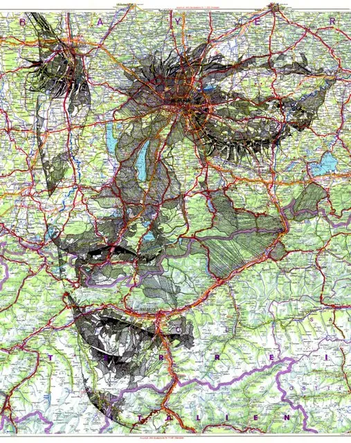
A talented artist has created breathtaking intimate portraits by using detailed maps of the world as his canvas. Cardiff-based illustrator, Ed Fairburn, combines the patchwork of roads, terrains and rivers to for his unique sketches. Photo: Ink on a 1977 road map of Germany. (Photo by Ed Fairburn/Rex Features)
Details
07 Jun 2013 11:04:00
Hawksbill Crag In The Ozark National Forest

The Hawksbill Crag, also known as Whitaker Point, is located along the northern edge of the Upper Buffalo Wilderness in the Ozark National Forest, just south of the Buffalo National River. It is easily one of the most photograped and recognizable features in Arkansas, and is often seen on publications depicting the outdoors in Arkansas. The hike to it is an easy 3.0 mile round trip, and offers scenic vistas, huge boulders, beautiful waterfalls and colorful wildflowers.
Details
21 Jun 2013 11:43:00
Abandon Village: Doel, Belgium

Doel is a 700 year old village on the river Scheldt in Belgium. Near to the local nuclear power plant, with its two giant cooling towers, it became the target for demolition not once but twice in order to make way for the ever expanding harbor. The successful protest groups of the seventies could not compete in the 90's and as residents began to leave, the government refused to rent out the properties again and instead let them fall into disrepair. On the 23rd of March 2007, the government decided that the village would be demolished by 2009 and in June 2008, residents received a letter informing them that they were to vacate their homes by the 1st of September 2009.
Details
20 Mar 2013 11:33:00
Vivid colors and bizarre shapes come together in a false-color image that could be an illustration for a fantasy story

Vivid colors and bizarre shapes come together in a false-color image that could be an illustration for a fantasy story. This labyrinth of exotic features winds its way along the edge of Russia’s Chaunskaya Bay in northeastern Siberia, seen as a vivid blue half-circle at the bottom of the image Two major rivers, the Chaun and Palyavaam, flow into the bay, which in turn opens into the Arctic Ocean. Ribbon lakes and bogs are present throughout the area, created by depressions left by receding glaciers. (Photo by USGS/NASA)
Details
14 Apr 2012 11:02:00
stone art by Hirotoshi Itoh

Hirotoshi Itoh graduated from Tokyo National Fine Arts University in 1982 and later went into his family business as a stonemason. He spent several years working with metal before turning his attention to stones. He utilizes stones found in a river bank near his home, and he creates sculptures that juxtapose the original shape and hardness of the material with surprising humor and texture. You can find more of his work on his Deviant Art page.
Details
17 May 2012 10:58:00
Kaindy Lake in Kazakhstan

Kaindy Lake (Kazakh: Қайыңды көлі, Qayındı köli) is a 400 metre long lake in Kazakhstan that reaches depths near 30 metres in some areas. It is located 129 km ESE of the city of Almaty and is 2,000 metres above sea level. It was created by the result of an enormous limestone landslide, triggered by the 1911 Kebin earthquake. The track to Kaindy lake has many scenic views to the Saty Gorge, the Chilik River valley and the Kaindy Gorge. Dried-out trunks of submerged Picea schrenkiana trees rise above the surface.
Details
06 Aug 2012 09:58:00
Victoria amazonica

The species has very large leaves, up to 3 m in diameter, that float on the water's surface on a submerged stalk, 7–8 m in length. The species was once called Victoria regia after Queen Victoria, but the name was superseded. V. amazonica is native to the shallow waters of the Amazon River basin, such as oxbow lakes and bayous. It is depicted in the Guyanese coat of arms. The flowers are white the first night they are open and become pink the second night. They are up to 40 cm in diameter, and are pollinated by beetles.
Details
03 Sep 2012 06:58:00
Sandstone sculpted by water and wind erosion is seen in a slot canyon, one of hundreds that surround Lake Powell near Page, Arizona, May 26, 2015. (Photo by Rick Wilking/Reuters)

Sandstone sculpted by water and wind erosion is seen in a slot canyon, one of hundreds that surround Lake Powell near Page, Arizona, May 26, 2015. Lake Powell on the Colorado River provides water for Nevada, Arizona and California. A severe drought in recent years, combined with withdrawals that many believe are not sustainable, has reduced its levels to only about 42 percent of its capacity. (Photo by Rick Wilking/Reuters)
Details
26 Nov 2015 08:01:00