Loading...
Done
Dragon Bridge Over The River Hang

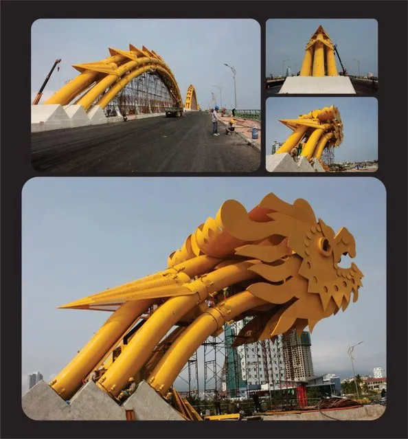
The Dragon Bridge (Vietnamese: Cầu Rồng) is a bridge over the River Hàn at Da Nang, Vietnam. Construction of the bridge began on 19 July 2009 (the same day as the inauguration of the nearby Thuận Phước Bridge) when the Prime Minister of Vietnam Nguyen Tan Dung and many high-ranking government officials attended the groundbreaking ceremony. Dragon Bridge is 666m long, 37.5m wide and has six lanes for traffic. It opened to traffic on March 29, 2013, at a cost os nearly VND 1.5 trillion dong (US$88m). The bridge was designed by the US-based Ammann & Whitney Consulting Engineers with Louis Berger Group. Construction was undertaken by Company No. 508, an affiliate of Civil Construction Engineering Corporation No.5, and Bridge Company No. 75.
Details
01 Jan 2014 08:41:00
Crystal Clear Waters Of Verzasca River

The Verzasca is a Swiss 30-km long mountain river originating at Pizzo Barone and flowing into Lake Maggiore. It is known for its clear turquoise water and vibrant colored rocks, as well as its treacherous currents. The Verzasca Dam is a few kilometers upriver from this lake.
Details
16 Oct 2013 10:59:00
An angler fishes on the opening day of the salmon fishing season on the River Tay at Kenmore in Scotland, Britain January 16, 2017. (Photo by Russell Cheyne/Reuters)

An angler fishes on the opening day of the salmon fishing season on the River Tay at Kenmore in Scotland, Britain January 16, 2017. (Photo by Russell Cheyne/Reuters)
Details
17 Jan 2017 12:18:00
Photograph shows a puppy holding a kitten, 1914. (Photo by Harry Whittier Frees/Library of Congress)

“Harry Whittier Frees (1879–1953) was an American photographer who created novelty postcards and children's books based on his photographs of animals. He dressed the animals and posed them in human situations with props, often with captions; these can be seen as progenitors of modern lolcats”. – Wikipedia. Photo: “The nurse”. Photograph shows a puppy holding a kitten, 1914. (Photo by Harry Whittier Frees/Library of Congress)

P.S. All pictures are presented in high resolution. To see Hi-Res images – just TWICE click on any picture. In other words, click small picture – opens the BIG picture. Click BIG picture – opens VERY BIG picture (if available; this principle works anywhere on the site AvaxNews).
Details
28 Mar 2014 11:20:00
The wreck of the Herald of Free Enterprise, which capsized near Zeebrugge on the 6th of March 1987

“MS Herald of Free Enterprise was a roll-on roll-off (RORO) car and passenger ferry owned by Townsend Thoresen. She was one of three ships commissioned by the company to operate on the Dover–Calais route across the English Channel. The ferry capsized on the night of 6 March 1987, moments after leaving the Belgian port of Zeebrugge, killing 193 passengers and crew. This was the deadliest maritime disaster involving a British ship in peacetime since the sinking of the Iolaire in 1919”. – Wikipedia

Photo: The wreck of the Herald of Free Enterprise, which capsized near Zeebrugge on the 6th of March 1987. (Photo by Hulton Archive/Getty Images). 1987
Details
06 Mar 2012 13:26:00
High winds blow sand across the highway near the original north shore of Owens Lake

High winds blow sand across the highway near the original north shore of Owens Lake, now miles from the nearest pool of water, on May 5, 2007 near Lone Pine, California. (Photo by David McNew/Getty Images)
Details
28 Sep 2011 11:33:00
Real-Time Face Tracking And Projection Mapping By Nobumichi Asai

Nobumichi Asai has used projection mapping to put CGI onto cars, docks, building and more. What is his latest canvas? A real, live human face! Asai used Omote, a combination of real-time face tracking and projection mapping to transform a model's face into mesmerizing patterns. It's called “electronic makeup”, but as you will see in the (creepy-ish) video, it goes much, much beyond anything makeup can possibly do.
Details
20 Aug 2014 10:49:00
Americans Try To Place European Countries On A Map Part 1

How sure are you of your geographical knowledge? Buzzfeed recently put Americans’ geographical knowledge to the test with a survey in which participants had to write in countries’ names on a blank European political map. Unfortunately, they didn’t fare too well, but some of their responses are hilarious (or hilariously mis-informed). But don’t be so quick to judge Americans – when Buzzfeed posted a similar survey testing Brits’ knowledge of the 50 United States, they also came up short. On the one hand, knowing a country’s states is different from knowing independent countries, but on the other, some U.S. states are larger than some European nations, and some U.S. states have larger economies than some European nations.
Details
02 Dec 2013 11:24:00