Loading...
Done
Daniel Filip, Tech Lead Manager for Google Maps, carries the Trekker, a 15-camera device, while mapping the Inca citadel of Machu Picchu for Google Street View in Cuzco, Peru, August 11, 2015. (Photo by Pilar Olivares/Reuters)

Daniel Filip, Tech Lead Manager for Google Maps, carries the Trekker, a 15-camera device, while mapping the Inca citadel of Machu Picchu for Google Street View in Cuzco, Peru, August 11, 2015. (Photo by Pilar Olivares/Reuters)
Details
07 Dec 2015 08:02:00
Metro map: Barcelona, Spain. (Photo by Jug Cerovic)

Metro map: Barcelona, Spain. (Photo by Jug Cerovic)
Details
22 Apr 2014 08:24:00
The Ultimate Bigot’s Calendar of the World

If you missed geography class in school here some maps to understand how the world looks! :)
Details
11 May 2012 05:34:00


Defined according to wikipedia it is “a recent and informal geologic chronological term that serves to mark the evidence and extent of human activities that have had a significant global impact on the Earth’s ecosystems. The term was coined by ecologist Eugene Stoermer but has been widely popularized by the Nobel Prize-winning atmospheric chemist Paul Crutzen.”

The images here where created by Felix Pharand-Deschenes depicting how various human influences, from road and rail, to internet cables and airlines create significant patterns covering the Earth. What can we learn from these patterns in how they are influencing the environment
Details
19 Aug 2012 10:40:00


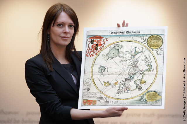
Head of European Prints, Severine Nackers holds a celestial Map of the Southern Sky by Albrecht Durer, at Sotheby's Auction House on March 25, 2011 in London, England. The two woodcut maps depicting the Northern and Southern skies circa 1515, are the earliest printed star charts of their kind ever published in Europe, and are expected to fetch between Ј120,000-180,000 GBP when they go on sale at the “London sale of Old Master, Modern and Contemporary prints” at Sotheby's Auction house on March 30, 2011. (Photo by Dan Kitwood/Getty Images)
Details
25 Mar 2011 14:57:00
Wonderful Food Maps By Henry Hargreaves And Caitlin Levin

Photographer Henry Hargreaves and artist Caitlin Levin have been working together for about decade. Their shared love for “food, photography, travel, and art” has found an outlet in a series of maps that they have illustrated with food.
Details
14 Aug 2014 10:21:00
Ink on a 1977 road map of Germany. (Photo by Ed Fairburn/Rex Features)

A talented artist has created breathtaking intimate portraits by using detailed maps of the world as his canvas. Cardiff-based illustrator, Ed Fairburn, combines the patchwork of roads, terrains and rivers to for his unique sketches. Photo: Ink on a 1977 road map of Germany. (Photo by Ed Fairburn/Rex Features)
Details
07 Jun 2013 11:04:00
Real-Time Face Tracking And Projection Mapping By Nobumichi Asai

Nobumichi Asai has used projection mapping to put CGI onto cars, docks, building and more. What is his latest canvas? A real, live human face! Asai used Omote, a combination of real-time face tracking and projection mapping to transform a model's face into mesmerizing patterns. It's called “electronic makeup”, but as you will see in the (creepy-ish) video, it goes much, much beyond anything makeup can possibly do.
Details
20 Aug 2014 10:49:00