Loading...
Done
Americans Try To Place European Countries On A Map Part 2

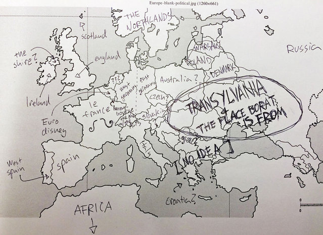
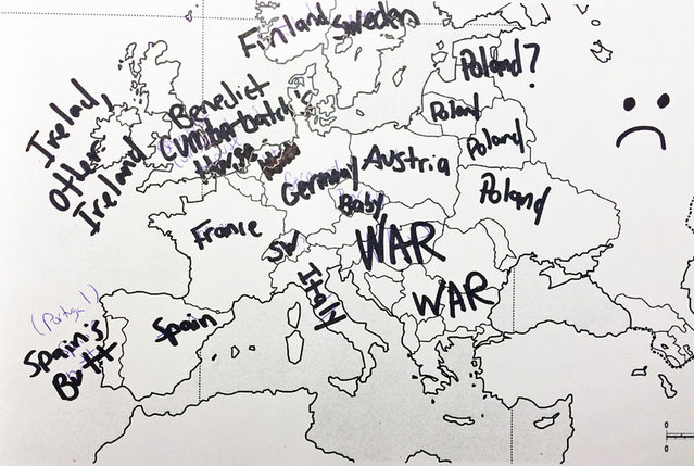
How sure are you of your geographical knowledge? Buzzfeed recently put Americans’ geographical knowledge to the test with a survey in which participants had to write in countries’ names on a blank European political map. Unfortunately, they didn’t fare too well, but some of their responses are hilarious (or hilariously mis-informed). But don’t be so quick to judge Americans – when Buzzfeed posted a similar survey testing Brits’ knowledge of the 50 United States, they also came up short. On the one hand, knowing a country’s states is different from knowing independent countries, but on the other, some U.S. states are larger than some European nations, and some U.S. states have larger economies than some European nations.
Details
03 Dec 2013 08:45:00
Real-Time Face Tracking And Projection Mapping By Nobumichi Asai

Nobumichi Asai has used projection mapping to put CGI onto cars, docks, building and more. What is his latest canvas? A real, live human face! Asai used Omote, a combination of real-time face tracking and projection mapping to transform a model's face into mesmerizing patterns. It's called “electronic makeup”, but as you will see in the (creepy-ish) video, it goes much, much beyond anything makeup can possibly do.
Details
20 Aug 2014 10:49:00
New 3-D Map of Massive Galaxies and Distant Black Holes Offers Clues to Dark Matter and Dark Energy

“The Sloan Digital Sky Survey III (SDSS-III) has released the largest-ever three-dimensional map of massive galaxies and distant black holes, which will help astronomers explain the mysterious “dark matter” and “dark energy” that scientists know makes up 96 percent of the Universe”. – SDSS-III
Details
10 Aug 2012 09:01:00
A woman wears VR glasses while the projection mapping is cast on table and walls during its media preview at “TREE BY NAKED, yoyogi park” restaurant in Tokyo, Japan on July 19, 2018. (Photo by Kim Kyung-Hoon/Reuters)

A woman wears VR glasses while the projection mapping is cast on table and walls during its media preview at “TREE BY NAKED, yoyogi park” restaurant in Tokyo, Japan on July 19, 2018. This restaurant incorporates virtual reality, projection mapping, and music to enhance diners' enjoyment of their food. (Photo by Kim Kyung-Hoon/Reuters)
Details
23 Jul 2018 00:03:00
Google Street View Captures Donkey Accident

When Google Maps was capturing images of a Street View in Botswana, it appeared that this donkey had been hit by a car. However, a representative from Google Maps has confirmed that the donkey was merely enjoying a roll in the dirt and is alive and well.
Details
20 Jan 2013 12:29:00
Jensen a two-year-old False Map turtle, from the Mississippi River, gets used to his new home at Blackpool Sea Life Centre

Jensen a two-year-old False Map turtle, from the Mississippi River, gets used to his new home at Blackpool Sea Life Centre on February 13, 2012 in Blackpool, England. (Photo by Christopher Furlong/Getty Images)
Details
13 Feb 2012 12:36:00
From Britain to China to Mali, new maps showing travel times to the nearest urban centre reveal huge differences between countries. Using Open Street Map and Google, a University of Oxford team have created a visual breakdown that suggests major inequalities when it comes to commuting. Here: China. The dataset used for China was unique as it relied solely on Open Street Map, due to restrictions on accessing Google data. The population is densely concentrated in the east and accessibility is increased, whereas rural provinces in the west remain remote. (Photo by Daniel Weiss/Jennifer Rozier/Malaria Atlas Project/University of Oxford )

From Britain to China to Mali, new maps showing travel times to the nearest urban centre reveal huge differences between countries. Using Open Street Map and Google, a University of Oxford team have created a visual breakdown that suggests major inequalities when it comes to commuting. Here: China. The dataset used for China was unique as it relied solely on Open Street Map, due to restrictions on accessing Google data. The population is densely concentrated in the east and accessibility is increased, whereas rural provinces in the west remain remote. (Photo by Daniel Weiss/Jennifer Rozier/Malaria Atlas Project/University of Oxford)
Details
12 Jan 2018 06:43:00
Women take part in the desert trek “Rose Trip Maroc”, on November 1, 2019 in the erg Chebbi near Merzouga. The Rose Trip Maroc is a female-oriented trek where teams of three must travel through the southern Moroccan Sahara desert with a compass, a map and a topographical reporter. (Photo by Jean-Philippe Ksiazek/AFP Photo)

Women take part in the desert trek “Rose Trip Maroc”, on November 1, 2019 in the erg Chebbi near Merzouga. The Rose Trip Maroc is a female-oriented trek where teams of three must travel through the southern Moroccan Sahara desert with a compass, a map and a topographical reporter. (Photo by Jean-Philippe Ksiazek/AFP Photo)
Details
04 Nov 2019 00:01:00