Loading...
Done
Prayers And Messages To God Are Removed From The Western Wall

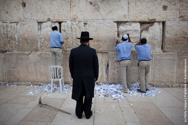
Men help remove messages and prayers written by thousands of people addressed to God from the cracks in the Western Wall in preparation for the up coming Jewish Passover holiday on March 28, 2012 in Jerusalem's old city, Israel. All the notes once collected will be buried in a special place at the Mount of Olives.according tro Jewish law. Passover begins in the evening of Friday, April 6 and commemorates the story of the Exodus where the ancient Israelites were freed from slavery in Egypt. (Photo by Uriel Sinai/Getty Images)
Details
29 Mar 2012 12:32:00
Revellers celebrate "Ash Monday" by participating in a colourful "flour war", a traditional festivity marking the end of the carnival season and the start of the 40-day Lent period until the Orthodox Easter,in the port town of Galaxidi, some 215 km (134 miles) north west of Athens, March 18, 2013. The revellers "fight" by throwing coloured flour, charcoal dust and powder painting until they essentially run out of supplies. (Photo by Yannis Behrakis/Reuters)

Revellers celebrate "Ash Monday" by participating in a colourful "flour war", a traditional festivity marking the end of the carnival season and the start of the 40-day Lent period until the Orthodox Easter,in the port town of Galaxidi, some 215 km (134 miles) north west of Athens, March 18, 2013. The revellers "fight" by throwing coloured flour, charcoal dust and powder painting until they essentially run out of supplies. (Photo by Yannis Behrakis/Reuters)
Details
20 Mar 2013 07:23:00
Ink on a 1977 road map of Germany. (Photo by Ed Fairburn/Rex Features)

A talented artist has created breathtaking intimate portraits by using detailed maps of the world as his canvas. Cardiff-based illustrator, Ed Fairburn, combines the patchwork of roads, terrains and rivers to for his unique sketches. Photo: Ink on a 1977 road map of Germany. (Photo by Ed Fairburn/Rex Features)
Details
07 Jun 2013 11:04:00


Head of European Prints, Severine Nackers holds a celestial Map of the Southern Sky by Albrecht Durer, at Sotheby's Auction House on March 25, 2011 in London, England. The two woodcut maps depicting the Northern and Southern skies circa 1515, are the earliest printed star charts of their kind ever published in Europe, and are expected to fetch between Ј120,000-180,000 GBP when they go on sale at the “London sale of Old Master, Modern and Contemporary prints” at Sotheby's Auction house on March 30, 2011. (Photo by Dan Kitwood/Getty Images)
Details
25 Mar 2011 14:57:00
Two ancient bronze coins, which according to Israel Antiquities Authority archaeologists were struck by the Roman procurator of Judea, Valerius Gratus, in the year 17/18 CE and recently were revealed in excavations beneath the Western Wall in Jerusalem's Old City

Two ancient bronze coins, which according to Israel Antiquities Authority archaeologists were struck by the Roman procurator of Judea, Valerius Gratus, in the year 17/18 CE and recently were revealed in excavations beneath the Western Wall in Jerusalem's Old City are exposed to the media' on November 23, 2011 in Israel. (Photo by Lior Mizrahi/Getty Images)
Details
24 Nov 2011 15:13:00
Americans Try To Place European Countries On A Map Part 1

How sure are you of your geographical knowledge? Buzzfeed recently put Americans’ geographical knowledge to the test with a survey in which participants had to write in countries’ names on a blank European political map. Unfortunately, they didn’t fare too well, but some of their responses are hilarious (or hilariously mis-informed). But don’t be so quick to judge Americans – when Buzzfeed posted a similar survey testing Brits’ knowledge of the 50 United States, they also came up short. On the one hand, knowing a country’s states is different from knowing independent countries, but on the other, some U.S. states are larger than some European nations, and some U.S. states have larger economies than some European nations.
Details
02 Dec 2013 11:24:00
Real-Time Face Tracking And Projection Mapping By Nobumichi Asai

Nobumichi Asai has used projection mapping to put CGI onto cars, docks, building and more. What is his latest canvas? A real, live human face! Asai used Omote, a combination of real-time face tracking and projection mapping to transform a model's face into mesmerizing patterns. It's called “electronic makeup”, but as you will see in the (creepy-ish) video, it goes much, much beyond anything makeup can possibly do.
Details
20 Aug 2014 10:49:00
This handout picture taken by Pleiades satellite and released on September 27, 2013 shows a small island of mud and rock created by the huge earthquake that hit southwest Pakistan has fascinated locals but experts – who found methane gas rising from it – say it is unlikely to last long

This handout picture taken by Pleiades satellite and released on September 27, 2013 shows a small island of mud and rock created by the huge earthquake that hit southwest Pakistan has fascinated locals but experts – who found methane gas rising from it – say it is unlikely to last long. The 7.7-magnitude quake struck on September 25 in Baluchistan's remote Awaran district, killing at least 271 people and affecting hundreds of thousands. The island is about 60 to 70 feet (18 to 21 metres) high, up to 300 feet wide and up to 120 feet long and sits about 650 feet from the coast. (Photo by AFP Photo/CNES/Distribution Astrium Services)
Details
01 Oct 2013 08:23:00