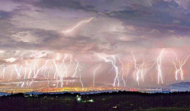
Loading...
Done
People walk in the rainstorm as typhoon Lekima approaches in Shanghai, China on August 10, 2019. (Photo by Aly Song/Reuters)

People walk in the rainstorm as typhoon Lekima approaches in Shanghai, China on August 10, 2019. The death toll from Typhoon Lekima rose to 49 on August 13 and 21 were still missing after the monster storm wreaked havoc on China's eastern coast, causing huge damage with strong gales and torrential rain. (Photo by Aly Song/Reuters)
Details
14 Aug 2019 00:01:00
A recently rescued grey seal pup looks up from its indoor kennel at the RSPCA West Hatch Wildlife Centre

A recently rescued grey seal pup looks up from its indoor kennel at the RSPCA West Hatch Wildlife Centre on January 9, 2012 in Taunton, England. The centre is currently dealing with a number of mainly grey seals that have been rescued from the coast due to the recent storms. Staff at the centre hope to release all the seals back into the wild by the spring. (Photo by Matt Cardy/Getty Images)
Details
10 Jan 2012 13:34:00
“Bamboo Mist”. (Photo by John Poppleton/Caters News)

A bodypainter uses UV paint to create electrifying masterpieces of stunning landscapes on models. John Poppletons vibrant Bodyscapes feature bright savannahs, lightning storms and vivid galaxies leaping from the bodies of his subjects. The artist, who lives in Wellsville in Utah, USA, uses a black light on his paintings to make them look as close to real life as possible. He predominantly uses female models and often paints across their backs to give him the largest surface area to work with. Here: “Bamboo Mist”. (Photo by John Poppleton/Caters News)
Details
17 Jul 2015 13:56:00
Fishermen move a fishing boat to a safer place along the shore ahead of cyclone Hudhud at Ganjam district in Odisha October 11, 2014. (Photo by Reuters/Stringer)

Fishermen move a fishing boat to a safer place along the shore ahead of cyclone Hudhud at Ganjam district in Odisha October 11, 2014. The India Meteorological Department described Cyclone Hudhud as a “very severe” storm that could pack winds of 195 kilometers (120 miles) per hour and cause torrential rains when it makes landfall near the port city of Visakhapatnam around noon Sunday. (Photo by Reuters/Stringer)
Details
13 Oct 2014 10:43:00
A supercell that spawned a tornado earlier makes it was east north of McLean, Texas  on April 16, 2015 in Texas, United States. (Photo by Mike Olbinski/Barcroft Media)

A supercell that spawned a tornado earlier makes it was east north of McLean, Texas on April 16, 2015 in Texas, United States. Huge hail, terrifying lighting and giant supercells the size of buildings – these incredible images depict a year in the life of a storm chaser. Shot in 2015 by photographer Mike Olbinski, 40, this series of pictures show both the beautiful and the extreme nature of weather in the United States. (Photo by Mike Olbinski/Barcroft Media)
Details
23 Dec 2015 08:06:00
NASA

In this handout image provided by NASA, the space shuttle Endeavour is seen on launch pad 39a as a storm passes by prior to the rollback of the Rotating Service Structure (RSS) April 28, 2011, at Kennedy Space Center in Cape Canaveral, Florida. During the 14-day mission, Endeavour and the STS-134 crew will deliver the Alpha Magnetic Spectrometer (AMS) and spare parts, including two S-band communications antennas, a high-pressure gas tank and additional spare parts for Dextre. Launch is targeted for April 29 at 3:47 p.m. EDT.
Details
30 Apr 2011 08:18:00
Hurricane Irene

In this handout GOES satellite image provided by the National Oceanic and Atmospheric Administration (NOAA), Irene reaches hurricane strength as it moves across Puerto Rico towards Hispaniola August 22, 2011 in the Caribbean Sea. Irene, the first hurricane of the Atlantic storm season, brought torrential rains and winds to Puerto Rico, downing trees and powerlines and flooding streets. The expected path will bring Irene through the Bahamas and is likely to hit Florida and up the east coast of the U.S. (Photo by NOAA via Getty Images)
Details
23 Aug 2011 12:47:00
Waves triggered by Typhoon Hato are seen in Hong Kong, China on August 23, 2017. (Photo by Tyrone Siu/Reuters)

Waves triggered by Typhoon Hato are seen in Hong Kong, China on August 23, 2017. A powerful typhoon barreled into Hong Kong on Wednesday, forcing offices and schools to close and leaving flooded streets, shattered windows and hundreds of canceled flights in its wake. Typhoon Hato came within 60 kilometers (37 miles) of Hong Kong, close enough to be considered a direct hit under Hong Kong's storm warning system. It was headed toward the western side of mainland China's Pearl River Delta. (Photo by Tyrone Siu/Reuters)
Details
24 Aug 2017 09:15:00