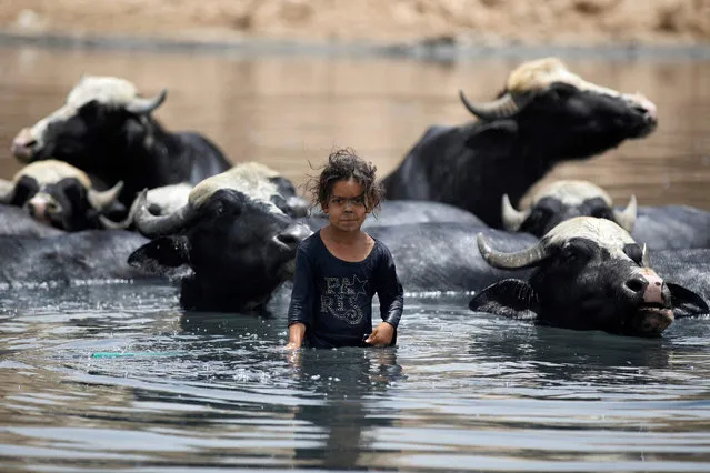
Loading...
Done
Son Doong Cave

Son doong cave is a cave in Phong Nha-Kẻ Bàng National Park, Bố Trạch district, Quảng Bình Province, Vietnam. Currently the biggest known cave in the world, the cave is located near the Laos-Vietnam border. Inside is a large, fast-flowing underground river.
In early August 2013, the first tourist group explored the cave on a guided tour at a cost of US$3,000 each. The group had six members from Australia, Norway, Russia and USA and spent 7 days and 6 nights for the tour. Next exploration trips will be arranged.
Details
22 Sep 2013 12:30:00
An aerial view of the lava erupting during volcanic eruption in September, in Bardarbunga, Iceland. (Photo by Örvar Atli Þorgeirsson/Barcroft Media)

An aerial view of the lava erupting during volcanic eruption in September, in Bardarbunga, Iceland. Lava spews out from craters as molten rock flows into a river down the Bardarbunga volcano in Iceland. The dramatic pictures of the Holuhraun eruption were taken from an altitude of 50-500m on September 5-9 by Örvar Atli Þorgeirsson at twilight and with the stunning Aurora Borealis in the background. (Photo by Örvar Atli Þorgeirsson/Barcroft Media)
Details
15 Sep 2014 10:52:00
Vivid colors and bizarre shapes come together in a false-color image that could be an illustration for a fantasy story

Vivid colors and bizarre shapes come together in a false-color image that could be an illustration for a fantasy story. This labyrinth of exotic features winds its way along the edge of Russia’s Chaunskaya Bay in northeastern Siberia, seen as a vivid blue half-circle at the bottom of the image Two major rivers, the Chaun and Palyavaam, flow into the bay, which in turn opens into the Arctic Ocean. Ribbon lakes and bogs are present throughout the area, created by depressions left by receding glaciers. (Photo by USGS/NASA)
Details
14 Apr 2012 11:02:00
Devil's Pool – Victoria Falls, Zambia. (Photo by Siena College Study Abroad)

“The Victoria Falls or Mosi-oa-Tunya is a waterfall located in southern Africa on the Zambezi River between the countries of Zambia and Zimbabwe. A famous feature is a naturally formed pool known as the Devil's Pool, near the edge of the falls, accessed via Livingstone Island in Zambia. When the river flow is at a certain level, usually during the months of September to December, a rock barrier forms a pool with little current; some people swim in the pool. Occasional deaths have been reported when people slip over the edge of the rock barrier”. – Wikipedia

Photo: Devil's Pool – Victoria Falls, Zambia. (Photo by Siena College Study Abroad)
Details
13 Dec 2012 12:46:00
Stunning images have revealed ice-cool British tourists chilling out inside Europe’s largest glacier – despite being at risk of flooding. The spectacular collection of images show the explorers braving the freezing temperatures to climb, photograph and even abseil down the inside of the icy cliff sides. Another image shows one visitor on his knees appearing to pray next to a water fall of melted ice. Other glistening shots show an adventurer trying to keep warm by a fire whose flames dance beautifully against the glossy roof. More shots show the caves sparkling like crystal with one ice formation appearing to resemble bubble wrap. In one picture, a brave tourist stands at the edge of a river flowing through the centre of the frosty caves. (Photo by Einar Runar Sigurdsson/Mediadrumworld.com)

Stunning images have revealed ice-cool British tourists chilling out inside Europe’s largest glacier – despite being at risk of flooding. The spectacular collection of images show the explorers braving the freezing temperatures to climb, photograph and even abseil down the inside of the icy cliff sides. Another image shows one visitor on his knees appearing to pray next to a water fall of melted ice. Other glistening shots show an adventurer trying to keep warm by a fire whose flames dance beautifully against the glossy roof. (Photo by Einar Runar Sigurdsson/Mediadrumworld.com)
Details
03 Dec 2016 11:36:00
Lava flows as volcano continues to erupt on the Canary island of La Palma, Spain, Monday, November 29, 2021. Several new volcanic vents opened in La Palma on Sunday, releasing new lava that flowed fast down a ridge and threatened to widen the impact on evacuated land, infrastructure and homes. (Photo by Emilio Morenatti/AP Photo)

Lava flows as volcano continues to erupt on the Canary island of La Palma, Spain, Monday, November 29, 2021. Several new volcanic vents opened in La Palma on Sunday, releasing new lava that flowed fast down a ridge and threatened to widen the impact on evacuated land, infrastructure and homes. (Photo by Emilio Morenatti/AP Photo)
Details
11 Dec 2021 08:42:00
People watch as lava flows from an eruption of a volcano on the Reykjanes Peninsula in southwestern Iceland late on Monday, March 29, 2021. Iceland's latest volcano eruption is still attracting crowds of people hoping to get close to the gentle lava flows. The eruption in Geldingadalur, near Iceland's capital Reykjavik, is not seen as a threat to nearby towns and the slow flows mean people can get close to action without too much harm. (Photo by Marco Di Marco/AP Photo)

People watch as lava flows from an eruption of a volcano on the Reykjanes Peninsula in southwestern Iceland late on Monday, March 29, 2021. Iceland's latest volcano eruption is still attracting crowds of people hoping to get close to the gentle lava flows. The eruption in Geldingadalur, near Iceland's capital Reykjavik, is not seen as a threat to nearby towns and the slow flows mean people can get close to action without too much harm. (Photo by Marco Di Marco/AP Photo)
Details
08 May 2021 09:04:00
This October 25, 2014 photo provided by the U.S. Geological Survey shows lava flow advancing across the pasture between the Pahoa cemetery and Apa'a Street, engulfing a barbed wire fence, near the town of Pahoa on the Big Island of Hawaii. (Photo by AP Photo/U.S. Geological Survey)

This October 25, 2014 photo provided by the U.S. Geological Survey shows lava flow advancing across the pasture between the Pahoa cemetery and Apa'a Street, engulfing a barbed wire fence, near the town of Pahoa on the Big Island of Hawaii. Dozens of residents in this rural area of Hawaii were placed on alert as flowing lava continued to advance. Authorities on Sunday, October 26, 2014 said lava had advanced about 250 yards since Saturday morning and was moving at the rate of about 10 to 15 yards an hour, consistent with its advancement in recent days. The flow front passed through a predominantly Buddhist cemetery, covering grave sites in the mostly rural region of Puna, and was roughly a half-mile from Pahoa Village Road, the main street of Pahoa. (Photo by AP Photo/U.S. Geological Survey)
Details
27 Oct 2014 11:47:00