Japanese team trains before the 6th FINA Synchronised Swimming World Trophy at the Water Cube on December 8, 2011 in Beijing, China. (Photo by Feng Li/Getty Images)
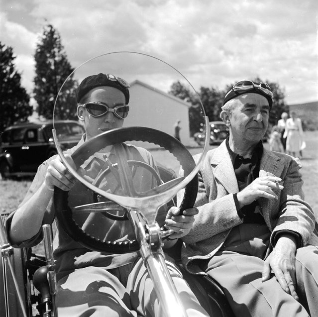
At the 50th anniversary of the Hartford Automobile Club a 1914 Mercer with an economical wind screen, looking like a large magnifying glass, designed to offer minimum wind resistance. Brass is used instead of chrome for the “shiny” parts, circa 1955. (Photo by Three Lions)
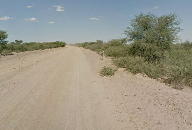
When Google Maps was capturing images of a Street View in Botswana, it appeared that this donkey had been hit by a car. However, a representative from Google Maps has confirmed that the donkey was merely enjoying a roll in the dirt and is alive and well.
A gorilla cube named Pepe eats frozen fruit to fight high temperatures at the Bioparc zoo in Valencia, eastern Spain, 28 June 2019. Spanish peninsula is suffering a heat wave with temperatures reaching up to 45 degrees. (Photo by Kai Foersterling/EPA/EFE/Rex Features/Shutterstock)
Crystal ice cubes at Jingyuetan National Forest Park attract tourists in Changchun City, northeast China's Jilin Province on January 10, 2024. (Photo by Splash News and Pictures)
A woman wears VR glasses while the projection mapping is cast on table and walls during its media preview at “TREE BY NAKED, yoyogi park” restaurant in Tokyo, Japan on July 19, 2018. This restaurant incorporates virtual reality, projection mapping, and music to enhance diners' enjoyment of their food. (Photo by Kim Kyung-Hoon/Reuters)
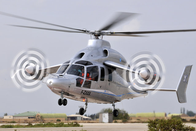
Eurocopter's X³ high-speed hybrid helicopter demonstrator performs, September 6, 2010. The Eurocopter X³ (X-Cubed) is an experimental high-speed compound helicopter developed by Eurocopter (now Airbus Helicopters). A technology demonstration platform for Eurocopter “high-speed, long-range hybrid helicopter” or H³ concept, the X³ achieved 255 knots in level flight on 7 June 2013, setting an unofficial speed record for a helicopter. (Photo by Reuters/HO/Eurocopter/Penna)
From Britain to China to Mali, new maps showing travel times to the nearest urban centre reveal huge differences between countries. Using Open Street Map and Google, a University of Oxford team have created a visual breakdown that suggests major inequalities when it comes to commuting. Here: China. The dataset used for China was unique as it relied solely on Open Street Map, due to restrictions on accessing Google data. The population is densely concentrated in the east and accessibility is increased, whereas rural provinces in the west remain remote. (Photo by Daniel Weiss/Jennifer Rozier/Malaria Atlas Project/University of Oxford)