Loading...
Done


PassCode – Bite the Bullet (Full Version) 【テレビ東京系ドラマ「フリンジマン」主題歌】
Details
26 Feb 2019 00:03:00


티아라 (T-ara) – 롤리폴리 (Roly Poly) Dance Cover by C.A.C’s Trainees Vietnam (K-pop in Public Challenge)
Details
05 Jun 2021 08:59:00


“With a fourth explosion rocking the Fukushima nuclear plant on Tuesday, danger of the spent nuke fuel pool boiling and radiation levels at the facility's gate increasing hundredfold, fears of a meltdown in Japan skyrocket”. – Russia Today

Photo: In this handout image provided by U.S. Navy, an aerial view of tsunami and earthquake damage is seen from an SH-60B helicopter assigned to the Chargers of Helicopter Antisubmarine Squadron (HS) 14 from Naval Air Facility Atsugi March 12, 2011 seen from the air of Sendai, Japan. (Photo by U.S. Navy via Getty Images)
Details
16 Mar 2011 10:19:00
Rob Heard's Wooden Bough House

Living on the edge of Exmoor, Rob takes his inspiration from the rolling countryside surrounding his home, where each Bough House sculpture takes several months to construct. The designs do not follow an explicit plan or process, each piece is unique. They evolve and flow freely, as part of a creative journey which has no natural limit, whilst also revealing great logic and engineering integrity. Every aerial walkway or staircase leads to a room - there are no dead-ends and every turret and tower can be reached.
Details
29 May 2013 10:31:00
Jeffrey Milstein captured these stunning images through the door of a helicopter hovering over central London. (Photo by Jeffrey Milstein/Rex Features/Shutterstock)

High-flying photographer Jeffrey Milstein, renowned for his aerial photos of US cities, snaps landmarks through the open door of a helicopter. This month he hired a chopper in London and amazingly he had just an hour to cover all the buildings he wanted to capture including Buckingham Palace, the London Eye, the glass roof of the British Museum and the Gherkin and Walkie Talkie towers in the City. Here: Jeffrey Milstein captured these stunning images through the door of a helicopter hovering over central London. (Photo by Jeffrey Milstein/Rex Features/Shutterstock)
Details
29 Sep 2016 09:22:00
Nicole Londraville works on aerial silks at Esh Circus Arts, a circus school and training center offering recreational circus instruction, in Somerville, Massachusetts May 7, 2014. (Photo by Brian Snyder/Reuters)

Movement is the essence and meaning of our life. We feel so much more alive when we are in motion, while people who spend hours motionless tend to have trouble connecting with the outside world. Whether you dive from a high cliff, play your favorite sport, dance at a rave party, or simply walk down a path with autumn leaves rustling under your feet with the love of your life by your side, all those things make your life richer, more beautiful, and more fulfilling. This set of pictures beautifully captures the joy of never-ending motion that enriches our life. (Photo by Brian Snyder/Reuters)
Details
16 Oct 2014 13:50:00
Natural gas plant in Pittsburg, CA (detail of Power Landscape), 2013. (Photo by Jenny Odell)

Jenny Odell repurposes online imagery mostly from Google Maps, but also from YouTube, Craigslist, and other sites. In her “Satellite Collections”, for example, she incorporated aerial views of swimming pools, basketball courts, parking lots, and other recognizable structures, seen from space. Her more recent series, “Satellite Landscapes”, includes painstakingly isolated Google Maps imagery of oil refineries, wastewater treatment plants, solar farms, etc. This work is meant as a reminder of our physically determined and vulnerable existence, since we depend on many of these things for survival and maintenance of our way of life. Photo: Natural gas plant in Pittsburg, CA (detail of Power Landscape), 2013. (Photo by Jenny Odell)
Details
19 Mar 2014 07:28:00


“NASA's Pathfinder, Pathfinder Plus, Centurion and Helios Prototype were an evolutionary series of solar- and fuel-cell-system-powered unmanned aerial vehicles. AeroVironment, Inc. developed the vehicles under NASA's Environmental Research Aircraft and Sensor Technology (ERAST) program. They were built to develop the technologies that would allow long-term, high-altitude aircraft to serve as “atmospheric satellites”, to perform atmospheric research tasks as well as serve as communications platforms”. – Wikipedia

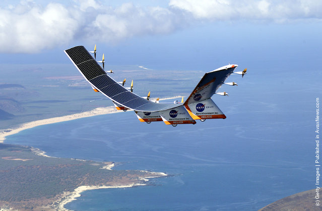
Photo: The solar-electric Helios Prototype flying wing is flies over the Hawaiian islands of Niihau and Lehua during the first solar-powered test flight July 14, 2001 from the U.S. Navy's Pacific Missile Range Facility on Kauai, HI. The 18-hour flight was a functional checkout of the aircraft's systems and performance in preparation for an attempt to reach sustained flight at 100,000 feet altitude later in the summer. (Photo Courtesy of NASA/Getty Images)
Details
14 Jul 2011 09:24:00