Loading...
Done
World's Biggest Copy Of Mona Lisa

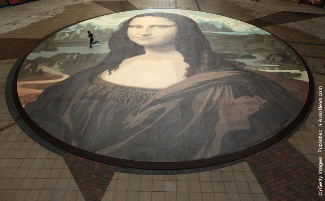
The world's biggest copy of the Mona Lisa is unveiled on October 28, 2009 in Wrexham, Wales The giant version of Leonardo da Vinci's masterpiece measures 17.5 metres across and is 50 times bigger than the original painting and was created by community groups in Wrexham and artist Katy Webster. (Photo by Christopher Furlong/Getty Images)
Details
27 Sep 2011 13:34:00
The World’s First ALL Diamond Ring

The world’s first all diamond ring was revealed by Shawish Jewelry and boasts 150 carats carved from a singe-faceted diamond. The all diamond ring costs a pretty penny at a whopping $68 million. I wonder with celebrity will try to nab it. The idea of an all diamond ring seemed to be a fantasy, yet the epitome of art.
Details
27 Mar 2014 19:05:00
Meet Boo – The World's Cutest Dog

Everyone loves Boo! His signature fluffy head and teddy bear like persona are irresistibly adorable. With nearly a million Facebook fans, and adding more each day, Boo is poised to become an international superstar.
Details
19 Nov 2012 13:08:00
A participant covers himself with a blanket as it rains at the venue of the World Culture Festival on the banks of a river in New Delhi, India, March 11, 2016. (Photo by Adnan Abidi/Reuters)

A participant covers himself with a blanket as it rains at the venue of the World Culture Festival on the banks of a river in New Delhi, India, March 11, 2016. (Photo by Adnan Abidi/Reuters)
Details
12 Mar 2016 15:07:00
Swimmers in fancy dress splash as they participate in the New Year's Day Loony Dook swim at South Queensferry, Scotland January 1, 2015. (Photo by Russell Cheyne/Reuters)

Swimmers in fancy dress splash as they participate in the New Year's Day Loony Dook swim at South Queensferry, Scotland January 1, 2015. (Photo by Russell Cheyne/Reuters)
Details
02 Jan 2015 12:33:00
Industrial Sector, Tokai, Japan. (Photo by Benjamin Grant/Digital Globe/Caters News)

This series of pictures shot by satellite, show the man-made world as astronauts see it. Artist Benjamin Grant uses Google Earth to find the most compelling satellite images of human civilization. The stunning pictures of sprawling metropolises and vast reservoirs are sometimes unidentifiable until zoomed in. In order to find an extraordinary picture in the practically endless supply of satellite data, Benjamin focuses on the themes of current events or environmental issues. Here: Industrial Sector, Tokai, Japan. (Photo by Benjamin Grant/Digital Globe/Caters News)
Details
04 Feb 2015 12:21:00
Miss India Manushi Chhilar (C) reacts as she wins the 67 th Miss World contest final next to France Aurore Andrée Raphaëlle Kichenin (R) and Miss Kenya Magline Jeruto (L) in Sanya, on the tropical Chinese island of Hainan on November 18, 2017. (Photo by Nicolas Asfouri/AFP Photo)

Miss India Manushi Chhilar (C) reacts as she wins the 67 th Miss World contest final next to France Aurore Andrée Raphaëlle Kichenin (R) and Miss Kenya Magline Jeruto (L) in Sanya, on the tropical Chinese island of Hainan on November 18, 2017. (Photo by Nicolas Asfouri/AFP Photo)
Details
20 Nov 2017 07:20:00
From Britain to China to Mali, new maps showing travel times to the nearest urban centre reveal huge differences between countries. Using Open Street Map and Google, a University of Oxford team have created a visual breakdown that suggests major inequalities when it comes to commuting. Here: China. The dataset used for China was unique as it relied solely on Open Street Map, due to restrictions on accessing Google data. The population is densely concentrated in the east and accessibility is increased, whereas rural provinces in the west remain remote. (Photo by Daniel Weiss/Jennifer Rozier/Malaria Atlas Project/University of Oxford )

From Britain to China to Mali, new maps showing travel times to the nearest urban centre reveal huge differences between countries. Using Open Street Map and Google, a University of Oxford team have created a visual breakdown that suggests major inequalities when it comes to commuting. Here: China. The dataset used for China was unique as it relied solely on Open Street Map, due to restrictions on accessing Google data. The population is densely concentrated in the east and accessibility is increased, whereas rural provinces in the west remain remote. (Photo by Daniel Weiss/Jennifer Rozier/Malaria Atlas Project/University of Oxford)
Details
12 Jan 2018 06:43:00